IMAGES TAKEN NEAR TO
Broadlands Avenue, BRIDGWATER, TA6 6QP
Introduction
This page details the photographs taken nearby to Broadlands Avenue, TA6 6QP by members of the Geograph project.
The Geograph project started in 2005 with the aim of publishing, organising and preserving representative images for every square kilometre of Great Britain, Ireland and the Isle of Man.

There are currently over 7.5m images from over14,400 individuals and you can help contribute to the project by visiting https://www.geograph.org.uk
Image Map
Images are licensed for reuse under creativecommons.org/licenses/by-sa/2.0
Notes
- Clicking on the map will re-center to the selected point.
- The higher the marker number, the further away the image location is from the centre of the postcode.
Image Listing (41 Images Found)
Images are licensed for reuse under creativecommons.org/licenses/by-sa/2.0
Image
Details
Distance
1
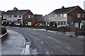
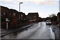
North Petherton : Broadlands Avenue
Broadlands Avenue which is a small residential street in North Petherton.
Image: © Lewis Clarke
Taken: 15 Feb 2014
0.01 miles
2
North Petherton : Broadlands Avenue
Broadlands Avenue seen from the junction with Parklands Close.
Image: © Lewis Clarke
Taken: 15 Feb 2014
0.04 miles
3
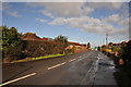
North Petherton : Bridggwater Road A38
The main road heading through the village of North Petherton.
Image: © Lewis Clarke
Taken: 15 Feb 2014
0.05 miles
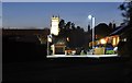
4
Bridgwater Road on outskirts of Nnrth Petherton
Image: © Roy Hughes
Taken: 26 Jun 2021
0.06 miles
5
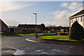
North Petherton : Parkfield Close
Parkfield Close which leads to a dead end and provides access to the housing along it.
Image: © Lewis Clarke
Taken: 15 Feb 2014
0.07 miles
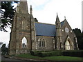
6
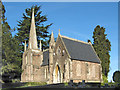
North Petherton : Sunnybrow Close
Looking along Sunnybrow Close and the church which stands out.
Image: © Lewis Clarke
Taken: 15 Feb 2014
0.09 miles
7
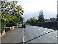
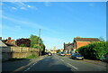
Bridgwater Road, North Petherton
The A38 heading north east.
Image: © JThomas
Taken: 10 May 2013
0.09 miles
10
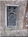
Ordnance Survey Flush Bracket (263)
This OS Flush Bracket can be found on the SW angle of the Mortuary Chapel. It marks a point 35.2827m above mean sea level.
Image: © Adrian Dust
Taken: 26 Apr 2015
0.13 miles