IMAGES TAKEN NEAR TO
School Fields, BRIDGWATER, TA6 6QJ
Introduction
This page details the photographs taken nearby to School Fields, TA6 6QJ by members of the Geograph project.
The Geograph project started in 2005 with the aim of publishing, organising and preserving representative images for every square kilometre of Great Britain, Ireland and the Isle of Man.

There are currently over 7.5m images from over14,400 individuals and you can help contribute to the project by visiting https://www.geograph.org.uk
Image Map (Loading...)


Getting Data...Please wait
Leaflet Map data © OpenStreetMap
Images are licensed for reuse under creativecommons.org/licenses/by-sa/2.0
Notes
- Clicking on the map will re-center to the selected point.
- The higher the marker number, the further away the image location is from the centre of the postcode.
Image Listing (119 Images Found)
Images are licensed for reuse under creativecommons.org/licenses/by-sa/2.0
Image
Details
Distance
1
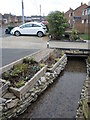
History almost right on the doorstep
These modern houses have a little water feature running underneath their drives. The water is a mill stream that used to run to a large pond (now built over) that serviced Baymead Corn Mill in years gone by.
Image: © Neil Owen
Taken: 23 Feb 2023
0.02 miles
2
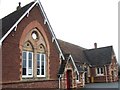
North Petherton Junior School
Separate boys and girls entrances still labelled at this Victorian school building on School Fields.
Image: © Derek Harper
Taken: 17 Feb 2007
0.06 miles
3
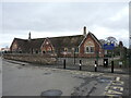
North Pertherton Primary school
The town has had a large number of eductional establishments dating back to the seventeenth century. It seems most were independent, if not unlicensed, and the religious communities also held Sunday schools as well. Today, some 400 young children of North Petherton are taught here.
Image: © Neil Owen
Taken: 23 Feb 2023
0.07 miles
4
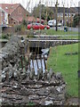
Back along School Fields
The former mill stream separates the houses from the road.
Image: © Neil Owen
Taken: 23 Feb 2023
0.08 miles
5
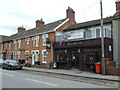
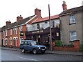
The Lamb Inn
A small pub in the middle of a suburban street, the pub is older than the houses to the left of shot.
Image: © Neil Owen
Taken: 23 Feb 2023
0.12 miles
8
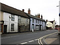
The corner of Fore Street and Queen Street
Queen Street stretches off the main road to join with Clare Street and on towards North Street. However, in the past Queen Street was called Back Lane and where it met Clare Street then became Pound Lane - as the animal pound was there.
A benchmark can be found on the corner of the Victorian brick house - see Image
Image: © Neil Owen
Taken: 23 Feb 2023
0.12 miles
9
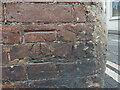
Fore Street benchmark
A cutmark of twentieth century designation on a house along the main road. See https://www.bench-marks.org.uk/bm69758 for the entry in the Benchmark Database and Image] for a wider look.
Image: © Neil Owen
Taken: 23 Feb 2023
0.12 miles
10
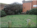
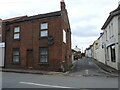
Space for a seat
The junction of Fore Street and School Lane has a small unbuilt space, with a bench for passers by. In the past this would have been houses and shops but they have been cleared.
Interestingly, there are three plaques on the seat: one marks the seventieth anniversary of the Women's Institute in 1997, one marks the 1st North Petherton Scouts work in creating the garden in the Scouts' movement's centenary in 2007, and the last commemorates Queen Elizabeth's Silver Jubilee.
Image: © Neil Owen
Taken: 23 Feb 2023
0.12 miles