IMAGES TAKEN NEAR TO
Baymead Lane, BRIDGWATER, TA6 6QD
Introduction
This page details the photographs taken nearby to Baymead Lane, TA6 6QD by members of the Geograph project.
The Geograph project started in 2005 with the aim of publishing, organising and preserving representative images for every square kilometre of Great Britain, Ireland and the Isle of Man.

There are currently over 7.5m images from over14,400 individuals and you can help contribute to the project by visiting https://www.geograph.org.uk
Image Map
Images are licensed for reuse under creativecommons.org/licenses/by-sa/2.0
Notes
- Clicking on the map will re-center to the selected point.
- The higher the marker number, the further away the image location is from the centre of the postcode.
Image Listing (90 Images Found)
Images are licensed for reuse under creativecommons.org/licenses/by-sa/2.0
Image
Details
Distance
1
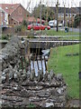
Back along School Fields
The former mill stream separates the houses from the road.
Image: © Neil Owen
Taken: 23 Feb 2023
0.04 miles
2
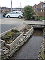
History almost right on the doorstep
These modern houses have a little water feature running underneath their drives. The water is a mill stream that used to run to a large pond (now built over) that serviced Baymead Corn Mill in years gone by.
Image: © Neil Owen
Taken: 23 Feb 2023
0.07 miles
3
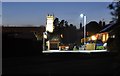
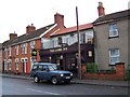
North Petherton : Sunnybrow Close
Looking along Sunnybrow Close and the church which stands out.
Image: © Lewis Clarke
Taken: 15 Feb 2014
0.09 miles
4
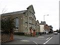
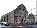
Congregational Church, North Petherton
Image: © Roger Cornfoot
Taken: 5 Mar 2011
0.11 miles
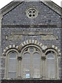
7
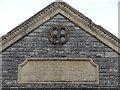
A high memorial
Inscribed stonework high above the old Congregational Church and Sunday school on Fore Street. It must be pretty uncommon for such a war memorial to be found on a rebuilt church. See Image] for a wider view.
Image: © Neil Owen
Taken: 23 Feb 2023
0.12 miles
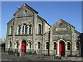
9
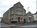
Ferrydown House
Now a healthcare facility for the local community, this was a Congregational church and Sunday school. See Image] and Image] for some interesting details of the frontage.
Image: © Neil Owen
Taken: 23 Feb 2023
0.12 miles
10
Rebuilt Congregational church
Originally founded in 1833 and rebuilt in 1869, this church has changed use: it is now a local authority healthcare facility. See Image] for a wider view of the old church and adjoining Sunday school.
Image: © Neil Owen
Taken: 23 Feb 2023
0.12 miles