IMAGES TAKEN NEAR TO
Shovel Road, BRIDGWATER, TA6 6NL
Introduction
This page details the photographs taken nearby to Shovel Road, TA6 6NL by members of the Geograph project.
The Geograph project started in 2005 with the aim of publishing, organising and preserving representative images for every square kilometre of Great Britain, Ireland and the Isle of Man.

There are currently over 7.5m images from over14,400 individuals and you can help contribute to the project by visiting https://www.geograph.org.uk
Image Map (Loading...)


Getting Data...Please wait
Leaflet Map data © OpenStreetMap
Images are licensed for reuse under creativecommons.org/licenses/by-sa/2.0
Notes
- Clicking on the map will re-center to the selected point.
- The higher the marker number, the further away the image location is from the centre of the postcode.
Image Listing (6 Images Found)
Images are licensed for reuse under creativecommons.org/licenses/by-sa/2.0
Image
Details
Distance
1
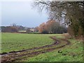
Trees and field near Daws Lane
Taken from just beyond the Image, across the small stream mentioned in Image, in which the colourful trees appear.
Image: © Derek Harper
Taken: 16 Jan 2010
0.09 miles
2

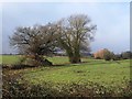
House near Shovel Farm
A fine square building with a solar panel.
Image: © Jonathan Billinger
Taken: 13 Mar 2007
0.17 miles
3
Trees near Daws Lane
From Image, looking to the right, up the shallow valley of a small stream towards Shovel Farm.
Image: © Derek Harper
Taken: 16 Jan 2010
0.21 miles
4
End of Daws Lane
This is how Image ends. Its continuation, as discussed in the description to that image, is pretty much a hedge and ditch going up the hill beyond; footpath BW 23/17 keeps on the left side of this. The frameworks of polytunnels by the pylon cross into Image
Image: © Derek Harper
Taken: 16 Jan 2010
0.24 miles
5
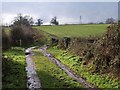
Daws Lane
This no through road, which has passed a few properties after leaving the A38, is still shown as a yellow road as it drops towards a small stream, where it terminates, but it would be tricky to negotiate in the average car, and there are no more turning points. The line of the lane is continued to Teckhill Lane by footpath BW 23/17, and doubtless the two were once connected, providing a through lane between North Petherton and Shearston.
Image: © Derek Harper
Taken: 16 Jan 2010
0.24 miles
6
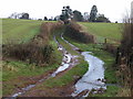
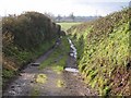
Daws Lane
A reverse view of Image The small stream mentioned in Image makes quite a big splash as it crosses the track. Footpath BW 23/17 passes through the first gap on the right, largely occupied by water.
Image: © Derek Harper
Taken: 16 Jan 2010
0.24 miles