IMAGES TAKEN NEAR TO
Dancing Hill, BRIDGWATER, TA6 6NE
Introduction
This page details the photographs taken nearby to Dancing Hill, TA6 6NE by members of the Geograph project.
The Geograph project started in 2005 with the aim of publishing, organising and preserving representative images for every square kilometre of Great Britain, Ireland and the Isle of Man.

There are currently over 7.5m images from over14,400 individuals and you can help contribute to the project by visiting https://www.geograph.org.uk
Image Map
Images are licensed for reuse under creativecommons.org/licenses/by-sa/2.0
Notes
- Clicking on the map will re-center to the selected point.
- The higher the marker number, the further away the image location is from the centre of the postcode.
Image Listing (108 Images Found)
Images are licensed for reuse under creativecommons.org/licenses/by-sa/2.0
Image
Details
Distance
1
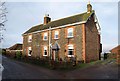
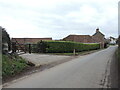
Dancing Hill Farm
Built of stone with brick surrounds to the windows and door and brick quoins, the farmhouse is at the foot of Dancing Hill.
Image: © Derek Harper
Taken: 16 Jan 2010
0.01 miles
2
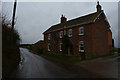
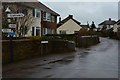
North Petherton : Dancing Hill
Looking along Dancing Hill with the farmhouse on the right.
Image: © Lewis Clarke
Taken: 20 Feb 2016
0.01 miles
3
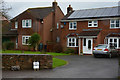
North Petherton : Dancing Hill Houses
Houses on Dancing Hill with one giving away free horse manure.
Image: © Lewis Clarke
Taken: 20 Feb 2016
0.02 miles
4
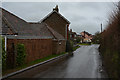
North Petherton : Dancing Hill
Looking along a road known as Dancing Hill.
Image: © Lewis Clarke
Taken: 20 Feb 2016
0.02 miles
5
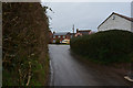
Along Dancing Hill
A farm on the delightfully named road.
Image: © Neil Owen
Taken: 23 Feb 2023
0.03 miles
6
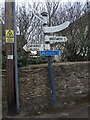
A bend in the road?
The signpost at Pilot's Helm appears to indicate that the local roads twist a bit. Oddly the bent arm has no text on the near side, although the back of it does say 'Broomfield 5'.
Image: © Neil Owen
Taken: 23 Feb 2023
0.04 miles
7
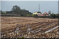
North Petherton : Field
A muddy field in the North Petherton surroundings.
Image: © Lewis Clarke
Taken: 20 Feb 2016
0.04 miles
8
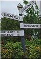
Old Direction Sign - Signpost by Dancing Hill, North Petherton Parish
Pyramid finial - 4 arms; Somerset SCC pyramid by the UC road, in parish of North Petherton (Sedgemoor District), Dancing Hill junction with North Street.
Surveyed
Milestone Society National ID: SO_ST2833C
Image: © Milestone Society
Taken: Unknown
0.04 miles
9
North Petherton : North Street
Looking along North Street in North Petherton.
Image: © Lewis Clarke
Taken: 20 Feb 2016
0.05 miles
10
North Petherton : High Street
The High Street heads from here towards Dancing Hill.
Image: © Lewis Clarke
Taken: 20 Feb 2016
0.05 miles