IMAGES TAKEN NEAR TO
Penlea Avenue, BRIDGWATER, TA6 6JU
Introduction
This page details the photographs taken nearby to Penlea Avenue, TA6 6JU by members of the Geograph project.
The Geograph project started in 2005 with the aim of publishing, organising and preserving representative images for every square kilometre of Great Britain, Ireland and the Isle of Man.

There are currently over 7.5m images from over14,400 individuals and you can help contribute to the project by visiting https://www.geograph.org.uk
Image Map (Loading...)


Getting Data...Please wait
Leaflet Map data © OpenStreetMap
Images are licensed for reuse under creativecommons.org/licenses/by-sa/2.0
Notes
- Clicking on the map will re-center to the selected point.
- The higher the marker number, the further away the image location is from the centre of the postcode.
Image Listing (9 Images Found)
Images are licensed for reuse under creativecommons.org/licenses/by-sa/2.0
Image
Details
Distance
5
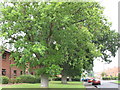
Oak trees on Rhode Lane
This is view of the oak trees on Rhode Lane, Bridgwater.
These are some of the oldest trees in the town and the care home
next to these acquired its name from these.
Image: © chris deane
Taken: 22 Jul 2011
0.15 miles
6
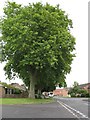
Oak trees on Rhode lane 2nd photo
These are oak trees on Rhode lane , Bridgwater
second photo , 2011 .
Image: © chris deane
Taken: 22 Jul 2011
0.16 miles
8
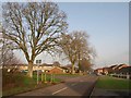
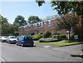
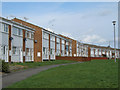
Rhode Lane, Hamp
The main road through the centre of the Hamp estate passes junctions with Risemoor Road on the left and Wills Road on the right.
Image: © Derek Harper
Taken: 26 Jan 2010
0.18 miles