IMAGES TAKEN NEAR TO
Elmside Road, BRIDGWATER, TA6 6JP
Introduction
This page details the photographs taken nearby to Elmside Road, TA6 6JP by members of the Geograph project.
The Geograph project started in 2005 with the aim of publishing, organising and preserving representative images for every square kilometre of Great Britain, Ireland and the Isle of Man.

There are currently over 7.5m images from over14,400 individuals and you can help contribute to the project by visiting https://www.geograph.org.uk
Image Map (Loading...)


Getting Data...Please wait
Leaflet Map data © OpenStreetMap
Images are licensed for reuse under creativecommons.org/licenses/by-sa/2.0
Notes
- Clicking on the map will re-center to the selected point.
- The higher the marker number, the further away the image location is from the centre of the postcode.
Image Listing (7 Images Found)
Images are licensed for reuse under creativecommons.org/licenses/by-sa/2.0
Image
Details
Distance
5
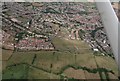
Cropmarks on the Meads between Durleigh Brook and Hamp Brook: aerial 2019 (3)
Image: © Chris
Taken: 8 Aug 2019
0.21 miles
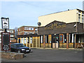
7
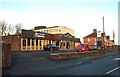
The Black Horse pub, Hamp
Looks like a 1960's pub in a large council estate.
Image: © Barbara Cook
Taken: 25 Nov 2006
0.24 miles