IMAGES TAKEN NEAR TO
Carnival Way, BRIDGWATER, TA6 6GY
Introduction
This page details the photographs taken nearby to Carnival Way, TA6 6GY by members of the Geograph project.
The Geograph project started in 2005 with the aim of publishing, organising and preserving representative images for every square kilometre of Great Britain, Ireland and the Isle of Man.

There are currently over 7.5m images from over14,400 individuals and you can help contribute to the project by visiting https://www.geograph.org.uk
Image Map
Images are licensed for reuse under creativecommons.org/licenses/by-sa/2.0
Notes
- Clicking on the map will re-center to the selected point.
- The higher the marker number, the further away the image location is from the centre of the postcode.
Image Listing (47 Images Found)
Images are licensed for reuse under creativecommons.org/licenses/by-sa/2.0
Image
Details
Distance
1
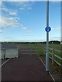
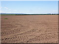
An extremely short cycle- and foot-path, Compass, Bridgwater
The signage is there in anticipation, but for the time being, nobody will use this path.
Image: © David Smith
Taken: 2 Jul 2022
0.03 miles
2
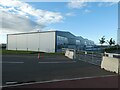
Industrial and business units, Compass Avenue, Bridgwater
Image: © David Smith
Taken: 2 Jul 2022
0.04 miles
3
Entrance to Costa coffee shop, Compass, Bridgwater
Image: © David Smith
Taken: 2 Jul 2022
0.09 miles
6
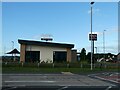
Costa drive-through coffee shop, Bridgwater
Image: © David Smith
Taken: 2 Jul 2022
0.09 miles
7
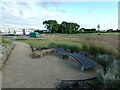
Sculpted chair, Compass Avenue, Bridgwater
On the partly developed business site at Compass Avenue
Image: © David Smith
Taken: 2 Jul 2022
0.10 miles
8

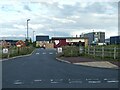
Road construction, Compass Avenue, Bridgwater
Image: © David Smith
Taken: 2 Jul 2022
0.10 miles
9
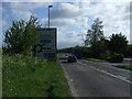
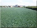
A38 approaching roundabout
Heading north east towards Bridgwater.
Image: © JThomas
Taken: 10 May 2013
0.11 miles
