IMAGES TAKEN NEAR TO
Sandalwood Ride, BRIDGWATER, TA6 6FF
Introduction
This page details the photographs taken nearby to Sandalwood Ride, TA6 6FF by members of the Geograph project.
The Geograph project started in 2005 with the aim of publishing, organising and preserving representative images for every square kilometre of Great Britain, Ireland and the Isle of Man.

There are currently over 7.5m images from over14,400 individuals and you can help contribute to the project by visiting https://www.geograph.org.uk
Image Map (Loading...)


Getting Data...Please wait
Leaflet Map data © OpenStreetMap
Images are licensed for reuse under creativecommons.org/licenses/by-sa/2.0
Notes
- Clicking on the map will re-center to the selected point.
- The higher the marker number, the further away the image location is from the centre of the postcode.
Image Listing (8 Images Found)
Images are licensed for reuse under creativecommons.org/licenses/by-sa/2.0
Image
Details
Distance
2
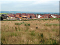
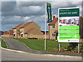
Wigeon Road, Quantock View, Bridgwater
One of several roads on the housing estate named after aquatic birds
Image: © David Smith
Taken: 2 Jul 2022
0.13 miles
3
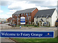
Friary Grange housing development, Bridgwater
Image: © Ken Grainger
Taken: 7 Apr 2009
0.13 miles
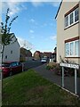
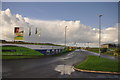
4
Charolais Drive, Stockmoor Park, Bridgwater
Image: © Ken Grainger
Taken: 7 Apr 2009
0.14 miles
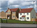
5
Stockmoor Park housing development, Bridgwater
Image: © Ken Grainger
Taken: 7 Apr 2009
0.15 miles
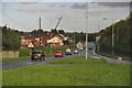
6
Access road to Dawes Farm business park
Image: © David Smith
Taken: 11 May 2018
0.22 miles
7
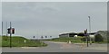
Bridgwater : Campion Way
Campion Way in the outskirts of Bridgwater as seen from a roundabout.
Image: © Lewis Clarke
Taken: 29 Oct 2013
0.23 miles
8
Bridgwater : Taunton Road A38
The A38 road heading around the outskirts of Bridgwater.
Image: © Lewis Clarke
Taken: 29 Oct 2013
0.24 miles