IMAGES TAKEN NEAR TO
Gloucester Road, BRIDGWATER, TA6 6DY
Introduction
This page details the photographs taken nearby to Gloucester Road, TA6 6DY by members of the Geograph project.
The Geograph project started in 2005 with the aim of publishing, organising and preserving representative images for every square kilometre of Great Britain, Ireland and the Isle of Man.

There are currently over 7.5m images from over14,400 individuals and you can help contribute to the project by visiting https://www.geograph.org.uk
Image Map
Images are licensed for reuse under creativecommons.org/licenses/by-sa/2.0
Notes
- Clicking on the map will re-center to the selected point.
- The higher the marker number, the further away the image location is from the centre of the postcode.
Image Listing (6 Images Found)
Images are licensed for reuse under creativecommons.org/licenses/by-sa/2.0
Image
Details
Distance
1
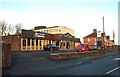
The Black Horse pub, Hamp
Looks like a 1960's pub in a large council estate.
Image: © Barbara Cook
Taken: 25 Nov 2006
0.16 miles
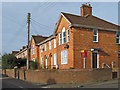
5
Wills Road, Bridgwater
The road curves around the southern side of the Hamp estate.
Image: © Derek Harper
Taken: 26 Jan 2010
0.23 miles
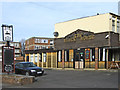
6
Regent Way, Bridgwater
A turning off Image into the Hamp estate; ahead is Ringwood Road.
Image: © Derek Harper
Taken: 26 Jan 2010
0.24 miles