IMAGES TAKEN NEAR TO
Sterling Way, TA6 6DA
Introduction
This page details the photographs taken nearby to Sterling Way, TA6 6DA by members of the Geograph project.
The Geograph project started in 2005 with the aim of publishing, organising and preserving representative images for every square kilometre of Great Britain, Ireland and the Isle of Man.

There are currently over 7.5m images from over14,400 individuals and you can help contribute to the project by visiting https://www.geograph.org.uk
Image Map
Images are licensed for reuse under creativecommons.org/licenses/by-sa/2.0
Notes
- Clicking on the map will re-center to the selected point.
- The higher the marker number, the further away the image location is from the centre of the postcode.
Image Listing (26 Images Found)
Images are licensed for reuse under creativecommons.org/licenses/by-sa/2.0
Image
Details
Distance
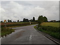
2

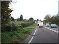
North Petherton : The A38
The A38 heading through the village of North Petherton.
Image: © Lewis Clarke
Taken: 15 Feb 2014
0.14 miles
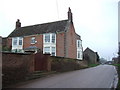
3
Where the corner shop used to be
Portman Road, North Petherton
Image: © Ken Grainger
Taken: 25 Jun 2009
0.14 miles
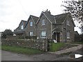
4
Batts House, North Petherton
A late C18 brick house with canted bays and attractive tented porch, on the hill south of the village. http://webapp1.somerset.gov.uk/her/details.asp?prn=13623
Image: © Derek Harper
Taken: 17 Feb 2007
0.14 miles
6
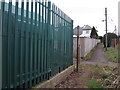
Prohibited in the lane
A faded sign by the electricity substation used to prohibit cycling.
Image: © Neil Owen
Taken: 23 Feb 2023
0.18 miles
7
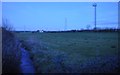
Sedgemoor : Grassy Field
A grassy field in the outskirts of North Petherton.
Image: © Lewis Clarke
Taken: 15 Feb 2014
0.18 miles
8
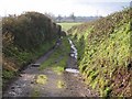
Daws Lane
This no through road, which has passed a few properties after leaving the A38, is still shown as a yellow road as it drops towards a small stream, where it terminates, but it would be tricky to negotiate in the average car, and there are no more turning points. The line of the lane is continued to Teckhill Lane by footpath BW 23/17, and doubtless the two were once connected, providing a through lane between North Petherton and Shearston.
Image: © Derek Harper
Taken: 16 Jan 2010
0.18 miles
9
A38 crossing a minor stream south of North Petherton
The stone bridge parapet is on the left.
Image: © David Smith
Taken: 5 Nov 2011
0.19 miles
10
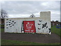
'Keep carm and carry on'
Might it be a local dialectic spelling or might it mean karma?
A brick structure of no immediately obvious purpose is decorated with some WWII images and the famous slogan. It may be worth wondering if the people who painted it and those who will pass by the scene know much about the actual Blitz, such is the increasing length of time now separating it.
Image: © Neil Owen
Taken: 23 Feb 2023
0.19 miles