IMAGES TAKEN NEAR TO
Pathfinder Terrace, Colley Lane, BRIDGWATER, TA6 5JH
Introduction
This page details the photographs taken nearby to Pathfinder Terrace, Colley Lane, TA6 5JH by members of the Geograph project.
The Geograph project started in 2005 with the aim of publishing, organising and preserving representative images for every square kilometre of Great Britain, Ireland and the Isle of Man.

There are currently over 7.5m images from over14,400 individuals and you can help contribute to the project by visiting https://www.geograph.org.uk
Image Map
Images are licensed for reuse under creativecommons.org/licenses/by-sa/2.0
Notes
- Clicking on the map will re-center to the selected point.
- The higher the marker number, the further away the image location is from the centre of the postcode.
Image Listing (126 Images Found)
Images are licensed for reuse under creativecommons.org/licenses/by-sa/2.0
Image
Details
Distance
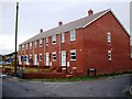
2

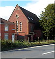
All Saints Terrace, Bridgwater
Row of houses extending for 55 metres, set back from the south side of the A372 Westonzoyland Road.
Image: © Jaggery
Taken: 3 Apr 2017
0.02 miles
5
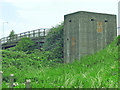
Pill box near Bridgwater Station
There's one at each end of this bridge, where the A372 crosses the railway. Part of the 'Taunton Stop Line', intended to halt any German advance into the West Country.
Image: © Ken Grainger
Taken: 17 Jul 2007
0.04 miles
6
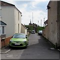
Oxford Terrace, Bridgwater
South along Oxford Terrace from St John Street towards steps up to the A372 Westonzoyland Road.
Image: © Jaggery
Taken: 3 Apr 2017
0.04 miles
7
Bridgwater Operatic Society club room entrance, Bridgwater
At the edge of All Saints Terrace, opposite the A372 Westonzoyland Road.
On April 3rd 2017, a poster advertises the society's
production of 42nd Street at the McMillan Theatre in early May 2017.
Image: © Jaggery
Taken: 3 Apr 2017
0.05 miles
8
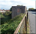
Pillbox on the west side of Westonzoyland Road railway bridge, Bridgwater
Located on the west side of Westonzoyland Road railway bridge. There is another pillbox on the east side of the bridge. http://www.geograph.org.uk/photo/3165512
The pillboxes were part of The Taunton Stop Line, a World War II defensive line in SW England. It was designed to stop an enemy's advance from the west and in particular a rapid advance supported by armoured fighting vehicles (up to the size of a German medium tank) which may have broken through the forward defences.
After the war, farmers on whose land the pillboxes had been built, were paid £5 for each one they demolished. However, most of the very solid structures have survived, though many are in varying stages of decay after seven decades.
Image: © Jaggery
Taken: 4 Oct 2012
0.05 miles
9
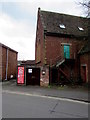
Eastern side of Eastover Youth & Community Centre, Bridgwater
Viewed across Westonzoyland Road.
Notices in front of the entrance on the western side show some of the users of the centre:
Budo Juku Martial Arts School;
Kyo-Kai Judo Club;
Little Angels Baby & Toddler Group.
The building looks like a former church. As the location is All Saints' Terrace,
a reasonable deduction is that this was formerly All Saints Church.
Image: © Jaggery
Taken: 4 Oct 2012
0.06 miles
10
Cars in the cabbage patch, Bridgwater
My walking companion commented that this looked like cars in the cabbage patch.
This is an area of grass in which there are some cabbages growing, which is used as a vehicle display area for Byron Wynn Autos, St John Street premises. Viewed from Westonzoyland Road (the A372).
Image: © Jaggery
Taken: 4 Oct 2012
0.06 miles