IMAGES TAKEN NEAR TO
St. John Street, BRIDGWATER, TA6 5JA
Introduction
This page details the photographs taken nearby to St. John Street, TA6 5JA by members of the Geograph project.
The Geograph project started in 2005 with the aim of publishing, organising and preserving representative images for every square kilometre of Great Britain, Ireland and the Isle of Man.

There are currently over 7.5m images from over14,400 individuals and you can help contribute to the project by visiting https://www.geograph.org.uk
Image Map (Loading...)


Getting Data...Please wait
Leaflet Map data © OpenStreetMap
Images are licensed for reuse under creativecommons.org/licenses/by-sa/2.0
Notes
- Clicking on the map will re-center to the selected point.
- The higher the marker number, the further away the image location is from the centre of the postcode.
Image Listing (161 Images Found)
Images are licensed for reuse under creativecommons.org/licenses/by-sa/2.0
Image
Details
Distance
1
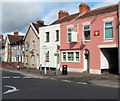
The Bristol & Exeter Inn, Bridgwater
The pink building is a pub at 135 St John Street, close to Bridgwater railway station. The name is a reference to the earliest days of the railway in Bridgwater when the Bristol and Exeter Railway opened its line from Bristol to the town in 1841.
At the early October 2012 date of this view, the pub name sign, hanging from a frame on the wall, is blank. There is no identification externally apart from a depiction of a setting or rising sun between two upstairs windows. The sign above the door shows Beck's Vier.
Is this a temporary absence of the name during repainting, or is there another reason?
Image: © Jaggery
Taken: 4 Oct 2012
0.01 miles
2
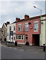
Bristol & Exeter Inn, Bridgwater
At 135 St John Street near Bridgwater railway station, which opened
in June 1841 on the opening of the Bristol and Exeter Railway line.
http://www.geograph.org.uk/photo/5342882 to the name sign.
Image: © Jaggery
Taken: 3 Apr 2017
0.01 miles
3
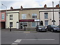
J E Gilbert & Son, St John Street, Bridgwater
Funeral directors and memorial consultants at 139 St John Street.
Image: © Jaggery
Taken: 3 Apr 2017
0.01 miles
4
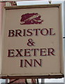
Bristol & Exeter Inn name sign, Bridgwater
Hanging from a wall bracket here. http://www.geograph.org.uk/photo/5342878
Image: © Jaggery
Taken: 3 Apr 2017
0.02 miles
5
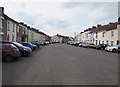
Bridgwater : St John Street
Looking along St John Street in Bridgwater.
Image: © Lewis Clarke
Taken: 20 Feb 2016
0.02 miles
6
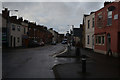
On-street parking, St John Street, Bridgwater
This quiet, wide part of St John Street is an unclassified road.
Beyond the Westonzoyland Road junction ahead, the A372 St John Street is narrower.
Image: © Jaggery
Taken: 3 Apr 2017
0.02 miles
7
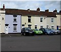
Cobwebs, St John Street, Bridgwater
No cars are parked in front of Cobwebs, a house on the north side of St John Street.
Image: © Jaggery
Taken: 3 Apr 2017
0.02 miles
8
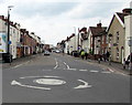
Mini-roundabout in St John Street, Bridgwater
The mini-roundabout at the A372 Westonzoyland Road junction is where
the unclassified St John Street behind the camera becomes the A372 St John Street ahead.
Image: © Jaggery
Taken: 3 Apr 2017
0.02 miles
9

Old-style sign at the Bridgwater end of Westonzoyland Road
On the wall on the right, an old-style sign points right towards
Westonzoyland (3¼ miles) and Langport (11½ miles). The houses on the left are in St John Street.
Image: © Jaggery
Taken: 4 Oct 2012
0.03 miles
10
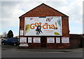
Gotcha! on a Westonzoyland Road wall, Bridgwater
On April 3rd 2017, a Sainsbury's advert on a Clear Channel board dominates the Westonzoyland Road wall near the corner of St John Street. Above the WESTONZOYLAND ROAD name sign, a direction sign shows Westonzoyland 3¼ (miles) Langport 11½.
Image: © Jaggery
Taken: 3 Apr 2017
0.03 miles