IMAGES TAKEN NEAR TO
Squibbers Way, BRIDGWATER, TA6 5FB
Introduction
This page details the photographs taken nearby to Squibbers Way, TA6 5FB by members of the Geograph project.
The Geograph project started in 2005 with the aim of publishing, organising and preserving representative images for every square kilometre of Great Britain, Ireland and the Isle of Man.

There are currently over 7.5m images from over14,400 individuals and you can help contribute to the project by visiting https://www.geograph.org.uk
Image Map (Loading...)


Getting Data...Please wait
Leaflet Map data © OpenStreetMap
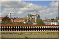
Images are licensed for reuse under creativecommons.org/licenses/by-sa/2.0
Notes
- Clicking on the map will re-center to the selected point.
- The higher the marker number, the further away the image location is from the centre of the postcode.
Image Listing (37 Images Found)
Images are licensed for reuse under creativecommons.org/licenses/by-sa/2.0
Image
Details
Distance
2
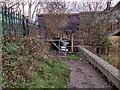
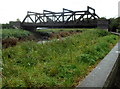
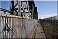
Barrier chicane on NCN3 in Bridgwater
A barrier chicane presenting an obstruction to access on NCN3 between Squibbers Way and River Lane in Bridgwater.
The gap through the chicane is narrow, and with the wall on the right presents a very difficult obstruction on the path, which is narrow and uneven here.
The underpass below the railway line is restricted as well - there is less than 6 feet of headroom here.
Image: © Kevin Pearson
Taken: 31 Dec 2021
0.15 miles
3
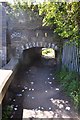
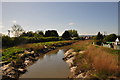
Bridgwater : Riverside Path & Tunnel
A path alongside the River Parrett which is you have to duck under to go underneath the railway
Image: © Lewis Clarke
Taken: 13 Apr 2014
0.15 miles
4
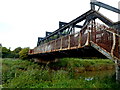
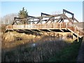
Rusty footbridge attached to Somerset Bridge, Bridgwater
On the west side of this http://www.geograph.org.uk/photo/4114802 railway bridge, the 40 metre long footbridge spans the River Parrett.
Image: © Jaggery
Taken: 4 Oct 2012
0.15 miles
5
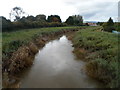
Downstream along the Parrett, Bridgwater
Viewed from this footbridge. http://www.geograph.org.uk/photo/4114807
Image: © Jaggery
Taken: 4 Oct 2012
0.16 miles
6
Bridgwater : River Parrett
From the footbridge looking down towards the River Parrett.
Image: © Lewis Clarke
Taken: 13 Apr 2014
0.16 miles
7
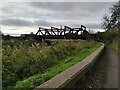
Somerset Bridge & NCN3 / NCN33 path
Somerset bridge between Dunwear and Bridgwater, carrying the railway over the River Parrett and the NCN3 / NCN33 path that runs alongside the river.
There is a footpath on the opposite (western) side of the bridge, accessed by steps.
The cyclepath goes through the brick archway at the end of the bridge - note that height through this archway is very restricted at less than 2m.
Image: © Kevin Pearson
Taken: 8 Nov 2021
0.16 miles
8
Somerset Bridge, Bridgwater
Steel girder railway bridge over the River Parrett.
Image: © Jaggery
Taken: 4 Oct 2012
0.16 miles
9
The main line from Taunton crosses Somerset Bridge
Image: © Roger Cornfoot
Taken: 11 Jan 2014
0.17 miles
10
Bridgwater : Footbridge
Along with the railway line, a footpath also heads across the River Parrett.
Image: © Lewis Clarke
Taken: 13 Apr 2014
0.17 miles