IMAGES TAKEN NEAR TO
Polden Street, BRIDGWATER, TA6 5EL
Introduction
This page details the photographs taken nearby to Polden Street, TA6 5EL by members of the Geograph project.
The Geograph project started in 2005 with the aim of publishing, organising and preserving representative images for every square kilometre of Great Britain, Ireland and the Isle of Man.

There are currently over 7.5m images from over14,400 individuals and you can help contribute to the project by visiting https://www.geograph.org.uk
Image Map
Images are licensed for reuse under creativecommons.org/licenses/by-sa/2.0
Notes
- Clicking on the map will re-center to the selected point.
- The higher the marker number, the further away the image location is from the centre of the postcode.
Image Listing (230 Images Found)
Images are licensed for reuse under creativecommons.org/licenses/by-sa/2.0
Image
Details
Distance
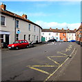
1
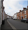
South along Polden Street, Bridgwater
Along Polden Street from the corner of Wellington Road towards St John Street.
Image: © Jaggery
Taken: 3 Apr 2017
0.01 miles
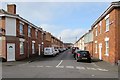
2
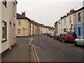
Polden Street, Bridgwater
The terraced street curves gracefully past the junction with Wellington Road.
Image: © Derek Harper
Taken: 26 Jan 2010
0.03 miles
3
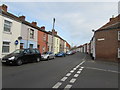
Junction of Polden Street and Wellington Road, Bridgwater
Wellington Road on the right joins Polden Street.
Image: © Jaggery
Taken: 3 Apr 2017
0.05 miles
4
Wellington Road Bridgwater
From the corner of Devonshire Street along Wellington Road towards Cornborough Place.
Image: © Jaggery
Taken: 3 Apr 2017
0.05 miles
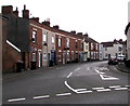
5
Zigzag markings on Wellington Road, Bridgwater
The yellow lines mark the Keep Clear Zone (no stopping or parking)
on the west side of Eastover Community Primary School.
Image: © Jaggery
Taken: 3 Apr 2017
0.05 miles
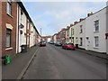
6
Northwest end of Wellington Road, Bridgwater
This part of Wellington Road is between the Polden Street junction in the foreground and the Cornborough Place junction in the background.
Image: © Jaggery
Taken: 3 Apr 2017
0.06 miles
7
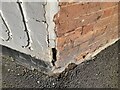
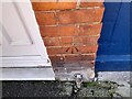
Ordnance Survey Cut Mark
This OS cut mark can be found on No1 Wellington Road. It marks a point 7.148m above mean sea level.
Image: © Adrian Dust
Taken: 16 Jan 2023
0.06 miles
8
Wellington Road side of Eastover Community Primary School Bridgwater
A rectangular sign on the wall shows
SOMERSET EDUCATION COMMITTEE
EASTOVER PRIMARY SCHOOL.
The red and white notice over the door shows
NO ENTRY FOR DELIVERY VEHICLES - USE CORNBOROUGH PLACE ENTRANCE.
This photo http://www.geograph.org.uk/photo/5335558 shows the Cornborough Place side of the school.
Image: © Jaggery
Taken: 3 Apr 2017
0.06 miles
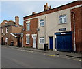
9
Devonshire Street Bridgwater
From Wellington Road along Devonshire Street towards Polden Street.
Image: © Jaggery
Taken: 3 Apr 2017
0.06 miles
10
Ordnance Survey Cut Mark
This OS cut mark can be found on No20 Devonshire Street. It marks a point 7.102m above mean sea level.
Image: © Adrian Dust
Taken: 16 Jan 2023
0.06 miles