IMAGES TAKEN NEAR TO
Ruborough Road, BRIDGWATER, TA6 5DL
Introduction
This page details the photographs taken nearby to Ruborough Road, TA6 5DL by members of the Geograph project.
The Geograph project started in 2005 with the aim of publishing, organising and preserving representative images for every square kilometre of Great Britain, Ireland and the Isle of Man.

There are currently over 7.5m images from over14,400 individuals and you can help contribute to the project by visiting https://www.geograph.org.uk
Image Map (Loading...)


Getting Data...Please wait
Leaflet Map data © OpenStreetMap
Images are licensed for reuse under creativecommons.org/licenses/by-sa/2.0
Notes
- Clicking on the map will re-center to the selected point.
- The higher the marker number, the further away the image location is from the centre of the postcode.
Image Listing (13 Images Found)
Images are licensed for reuse under creativecommons.org/licenses/by-sa/2.0
Image
Details
Distance
1
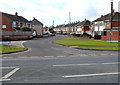
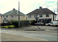
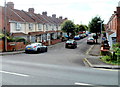
Sedgemoor Road, Bridgwater
This road has a slight bend as it joins the A372. This appears to correspond to a track marked in a mid-20th century OS map
Image: © David Smith
Taken: 3 Jul 2022
0.06 miles
2
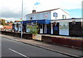
Pig & Whistle Pub
On the Parkway, Sydenham, Bridgwater
Image: © Adrian and Janet Quantock
Taken: 18 Feb 2006
0.07 miles
3
Sedgemoor Road, Bridgwater
Viewed across Westonzoyland Road.
Image: © Jaggery
Taken: 4 Oct 2012
0.07 miles
4
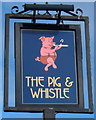
The Pig & Whistle pub sign, Bridgwater
The pub sign hangs from a post at the Parkway edge of the pub. http://www.geograph.org.uk/photo/3165592
Image: © Jaggery
Taken: 4 Oct 2012
0.12 miles
5
The Pig & Whistle, Bridgwater
Pub at the southern end of Parkway. http://www.geograph.org.uk/photo/3165586
Image: © Jaggery
Taken: 4 Oct 2012
0.13 miles
6
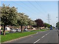
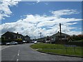
Parkway, Sydenham
A very distinctive street, dual carriageway with a powerline down the middle.
Image: © Richard Webb
Taken: 19 Apr 2011
0.17 miles
7
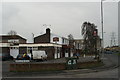
Dolphin Fish Bar, Bridgwater
Fish and chip shop on the corner of Westonzoyland Road and Penzoy Avenue.
Image: © Jaggery
Taken: 4 Oct 2012
0.17 miles
8
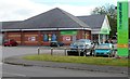
The Co-operative Food store, The Redgate Centre, Bridgwater
Formerly a Somerfield store, on the corner of Clarks Road and Westonzoyland Road.
Image: © Jaggery
Taken: 4 Oct 2012
0.17 miles
9
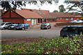
Redgate Medical Centre, Bridgwater
On the north side of Westonzoyland Road, between Redgate Street and Clarks Road.
There is a Lloyds Pharmacy on the left.
Image: © Jaggery
Taken: 4 Oct 2012
0.22 miles
10
Loxleigh Avenue, Bridgwater
Viewed from Westonzoyland Road.
Image: © Jaggery
Taken: 4 Oct 2012
0.24 miles