IMAGES TAKEN NEAR TO
Salmon Parade, BRIDGWATER, TA6 5AN
Introduction
This page details the photographs taken nearby to Salmon Parade, TA6 5AN by members of the Geograph project.
The Geograph project started in 2005 with the aim of publishing, organising and preserving representative images for every square kilometre of Great Britain, Ireland and the Isle of Man.

There are currently over 7.5m images from over14,400 individuals and you can help contribute to the project by visiting https://www.geograph.org.uk
Image Map (Loading...)


Getting Data...Please wait
Leaflet Map data © OpenStreetMap
Images are licensed for reuse under creativecommons.org/licenses/by-sa/2.0
Notes
- Clicking on the map will re-center to the selected point.
- The higher the marker number, the further away the image location is from the centre of the postcode.
Image Listing (496 Images Found)
Images are licensed for reuse under creativecommons.org/licenses/by-sa/2.0
Image
Details
Distance
1
Collapsing flood wall, Bridgwater
On 4th November 2011 a section of the flood wall alongside the River Parrett started to collapse. It has been back filled with concrete but engineers are waiting for it to collapse entirely before effecting a permanent repair.
Image: © Ken Grainger
Taken: 12 Nov 2011
0.01 miles
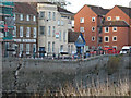
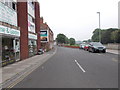
2
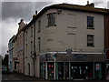
Salmon Parade
Looking towards Bridgwater Hospital at the end of the road. Note old advertising above the garish modern billboard.
Image: © Elaine Smith
Taken: 25 Jul 2008
0.02 miles
3
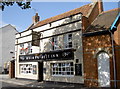
River Parrett Inn
Looking over the banks of the river, where else would it be?
Image: © Neil Owen
Taken: 5 Sep 2013
0.02 miles
4
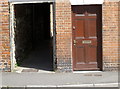
Salmon Parade
A row of terraced houses along the banks of the river Parrett, with a side entrance. The house also boasts a benchmark - see Image
Image: © Neil Owen
Taken: 30 Aug 2012
0.02 miles
5
Benchmark at number one
The familiar benchmark can be seen between the side entrance and the front door, and the entry in the Benchmark Database: http://www.bench-marks.org.uk/bm46233 . Also see Image] for a wider view.
Image: © Neil Owen
Taken: 30 Aug 2012
0.02 miles
6
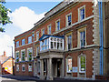
Bridgwater Hospital
Adapted from existing houses in 1820.
Image: © Ken Grainger
Taken: 11 Jul 2007
0.02 miles
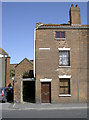
7
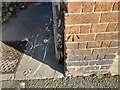
Ordnance Survey Cut Mark
This OS cut mark can be found on No1 Salmon Parade. It marks a point 8.041m above mean sea level.
Image: © Adrian Dust
Taken: 16 Jan 2023
0.02 miles
8
Corner of Eastover and East Quay
Looking down towards the Taxi rank
Image: © Elaine Smith
Taken: 25 Jul 2008
0.03 miles
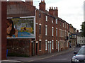
9
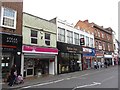
Eastover, Bridgwater
A selection of shops and restaurants east of the river.
Image: © Richard Webb
Taken: 31 Mar 2012
0.03 miles
10
Salmon Parade - viewed from East Quay
Image: © Betty Longbottom
Taken: 9 Jun 2016
0.03 miles