IMAGES TAKEN NEAR TO
Jade Close, BRIDGWATER, TA6 4WR
Introduction
This page details the photographs taken nearby to Jade Close, TA6 4WR by members of the Geograph project.
The Geograph project started in 2005 with the aim of publishing, organising and preserving representative images for every square kilometre of Great Britain, Ireland and the Isle of Man.

There are currently over 7.5m images from over14,400 individuals and you can help contribute to the project by visiting https://www.geograph.org.uk
Image Map (Loading...)


Getting Data...Please wait
Leaflet Map data © OpenStreetMap
Images are licensed for reuse under creativecommons.org/licenses/by-sa/2.0
Notes
- Clicking on the map will re-center to the selected point.
- The higher the marker number, the further away the image location is from the centre of the postcode.
Image Listing (9 Images Found)
Images are licensed for reuse under creativecommons.org/licenses/by-sa/2.0
Image
Details
Distance
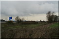
1
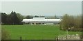
Willowdown Primary Academy
The new school on the northeast edge of Bridgwater, seen from the M5.
Image: © Derek Harper
Taken: 20 Apr 2016
0.13 miles
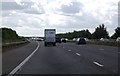

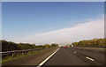
5
Sedgemoor : M5 Motorway
The M5 Motorway between Junction 24 (Huntworth Interchange) and Junction 23 (Dunball).
Image: © Lewis Clarke
Taken: 30 Sep 2018
0.24 miles
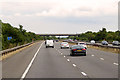
6
Field & M5
In the background you can just make out a wicker man sculpture.
Image: © Adrian and Janet Quantock
Taken: 18 Feb 2006
0.24 miles
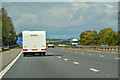
8
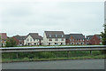
King's Down
Part of a new expansion of Bridgwater as seen from the M5.
Image: © Bill Boaden
Taken: 25 May 2018
0.25 miles
9
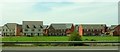
New housing, Bridgwater
On Mayfair Close, and seen from the M5.
Image: © Derek Harper
Taken: 20 Apr 2016
0.25 miles