IMAGES TAKEN NEAR TO
Douai Gardens, BRIDGWATER, TA6 4UP
Introduction
This page details the photographs taken nearby to Douai Gardens, TA6 4UP by members of the Geograph project.
The Geograph project started in 2005 with the aim of publishing, organising and preserving representative images for every square kilometre of Great Britain, Ireland and the Isle of Man.

There are currently over 7.5m images from over14,400 individuals and you can help contribute to the project by visiting https://www.geograph.org.uk
Image Map (Loading...)


Getting Data...Please wait
Leaflet Map data © OpenStreetMap
Images are licensed for reuse under creativecommons.org/licenses/by-sa/2.0
Notes
- Clicking on the map will re-center to the selected point.
- The higher the marker number, the further away the image location is from the centre of the postcode.
Image Listing (22 Images Found)
Images are licensed for reuse under creativecommons.org/licenses/by-sa/2.0
Image
Details
Distance
1
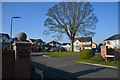
Pawlett : Manor Park
One sign reads Manor Fields but another Manor Park.
Image: © Lewis Clarke
Taken: 24 Feb 2018
0.09 miles
2

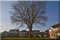
Pawlett : Manor Park
A tree dominates this area of Manor Park.
Image: © Lewis Clarke
Taken: 24 Feb 2018
0.09 miles
3
Pawlett : Manor Park
A road and area known as Manor Park.
Image: © Lewis Clarke
Taken: 24 Feb 2018
0.09 miles
4
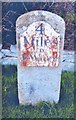
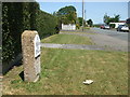
Old Milestone by Manor Road, Pawlett Parish
Metal plate attached to stone post by the UC road (was A38), in parish of PAWLETT (SEDGEMOOR District), Manor Road (Old Main Road), opposite No. 26, on grass verge, in front of garden boundary, on West side of road. Bridgewater iron plate, erected by the Bridgwater turnpike trust in the 19th century.
Inscription reads:-
4
Miles
To
B Water
Milestone Society National ID: SO_BGHB04.
Image: © JR Dowding
Taken: 17 Feb 2008
0.12 miles
5
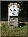
Pawlett milestone
An interesting specimen: this milestone has clearly been treated to a bit of attention and is standing proudly in the sunshine on Manor Road. However, a little research of old maps show a milestone on this road but further south and on the other side of the road. (Approximate grid references for the latter may be Image) The maps also give the legend 'Cross 12, Bridgwater 4'. See Image] for a look at the top.
Image: © Neil Owen
Taken: 25 May 2020
0.12 miles
6

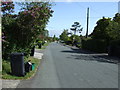
Pawlett : Pawlett Road A38
A road heading out from Pawlett and onwards towards Huntspill.
Image: © Lewis Clarke
Taken: 24 Feb 2018
0.12 miles
7
Manor Road and 4 miles to Bridgwater
A well-tended milestone in Pawlett. But this does not appear to be the correct place for it - old maps show it to be a short distance south and on the other side of the road! Has this stone been shifted or even totally replaced? See Image] for a better look and a bit more information.
Image: © Neil Owen
Taken: 25 May 2020
0.13 miles
8

Top of the Manor Road milestone
The milestone appears to have a Rivet benchmark, and possibly an older version in the depression in the middle. Oddly, the milestone today is not in the original position as marked on old maps, nor did it have a benchmark - so perhaps this is a replacement stone from elsewhere? See Image] for a contextual view.
Image: © Neil Owen
Taken: 25 May 2020
0.13 miles
10
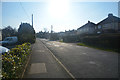
Pawlett : Manor Road
A road heading through the village of Pawlett.
Image: © Lewis Clarke
Taken: 24 Feb 2018
0.14 miles