IMAGES TAKEN NEAR TO
Bath Road, BRIDGWATER, TA6 4PW
Introduction
This page details the photographs taken nearby to Bath Road, TA6 4PW by members of the Geograph project.
The Geograph project started in 2005 with the aim of publishing, organising and preserving representative images for every square kilometre of Great Britain, Ireland and the Isle of Man.

There are currently over 7.5m images from over14,400 individuals and you can help contribute to the project by visiting https://www.geograph.org.uk
Image Map (Loading...)


Getting Data...Please wait
Leaflet Map data © OpenStreetMap
Images are licensed for reuse under creativecommons.org/licenses/by-sa/2.0
Notes
- Clicking on the map will re-center to the selected point.
- The higher the marker number, the further away the image location is from the centre of the postcode.
Image Listing (88 Images Found)
Images are licensed for reuse under creativecommons.org/licenses/by-sa/2.0
Image
Details
Distance
1
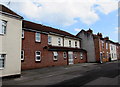
Union Street flats, Bridgwater
One front door leads to flats set back slightly from adjacent houses.
Image: © Jaggery
Taken: 3 Apr 2017
0.04 miles
2
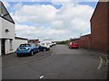
Union Street side road, Bridgwater
Aligned at right angles to the main course of Union Street,
this side road extends for 50 metres to waste ground at the edge
of the site formerly occupied by Bridgwater Cattle Market.
Image: © Jaggery
Taken: 3 Apr 2017
0.05 miles
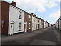
3
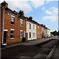
Houses near the southeast end of Union Street Bridgwater
Looking towards the A39 Bath Road.
Image: © Jaggery
Taken: 3 Apr 2017
0.05 miles
4
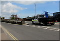
Junction of Lower Bath Road and Bath Road, Bridgwater
Lower Bath Road on the left is a dead end road.
The A39 Bath Road ascends towards Bath Bridge over railway lines.
Image: © Jaggery
Taken: 3 Apr 2017
0.05 miles
5
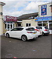
Mings Chinese takeaway, Bath Road, Bridgwater
The Cantonese cuisine takeaway is next door to Kebab Kitchen
Image: © Jaggery
Taken: 3 Apr 2017
0.05 miles
6
Metal posts across the southeast end of Union Street, Bridgwater
About 30 metres from the A39 Bath Road junction behind the camera, metal posts prevent the passage of motor vehicles wider than a motorbike. There are also barriers 110 metres ahead, http://www.geograph.org.uk/photo/5351076 near the A38 Bristol Road.
Image: © Jaggery
Taken: 3 Apr 2017
0.06 miles
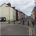
7
Union Street, Bridgwater
Between the A38 Bristol Road and the A39 Bath Road.
Image: © Jaggery
Taken: 3 Apr 2017
0.06 miles
8
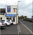
Kebab Kitchen, Lower Bath Road, Bridgwater
Takeaway (burgers, pizzas, kebabs etc) opposite the junction of Lower Bath Road and the A39 Bath Road.
Image: © Jaggery
Taken: 3 Apr 2017
0.06 miles
9
Curry Leaf Bridgwater
Indian takeaway at 77 Bath Road on the corner of Union Street.
Image: © Jaggery
Taken: 3 Apr 2017
0.06 miles
10
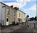
Southeast end of Union Street, Bridgwater
Number 1 Union Street is on the left.
On the right is the side of the Curry Leaf Indian takeaway http://www.geograph.org.uk/photo/5335616 at 77 Bath Road.
Image: © Jaggery
Taken: 3 Apr 2017
0.06 miles