IMAGES TAKEN NEAR TO
Bath Road, BRIDGWATER, TA6 4NZ
Introduction
This page details the photographs taken nearby to Bath Road, TA6 4NZ by members of the Geograph project.
The Geograph project started in 2005 with the aim of publishing, organising and preserving representative images for every square kilometre of Great Britain, Ireland and the Isle of Man.

There are currently over 7.5m images from over14,400 individuals and you can help contribute to the project by visiting https://www.geograph.org.uk
Image Map (Loading...)


Getting Data...Please wait
Leaflet Map data © OpenStreetMap
Images are licensed for reuse under creativecommons.org/licenses/by-sa/2.0
Notes
- Clicking on the map will re-center to the selected point.
- The higher the marker number, the further away the image location is from the centre of the postcode.
Image Listing (13 Images Found)
Images are licensed for reuse under creativecommons.org/licenses/by-sa/2.0
Image
Details
Distance
1
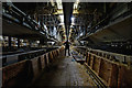
British Cellophane
Interior of the CS2 recovery line in the now demolished British Cellophane plant
Image: © Noel Jenkins
Taken: 23 Jan 2010
0.18 miles
2

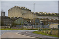
British Cellophane
View over the former British Cellophane site taken while demolition was in progress. The site is now being redeveloped. Despite still being a profitable business, the factory was closed by the owners Innovia Films in 2005 with the loss of 250 jobs.
Image: © Noel Jenkins
Taken: 23 Jan 2010
0.20 miles
3
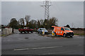
Bridgwater : Bath Road - Breakdown
A breakdown recovery van from the RAC has come to the rescue here on Bath Road.
Image: © Lewis Clarke
Taken: 20 Feb 2016
0.21 miles
4
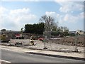
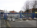
Road construction, Bridgwater
A new road being built by the site of the British Cellophane factory.
Image: © Richard Webb
Taken: 21 Apr 2011
0.21 miles
5
Bridgwater : King's Drive
Looking towards a factory on King's Drive from Bath Road.
Image: © Lewis Clarke
Taken: 20 Feb 2016
0.21 miles
6
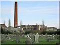
St John's Cemetery, Bridgwater
And the derelict Innovia cellophane factory.
Image: © Ken Grainger
Taken: 12 Nov 2008
0.22 miles
8
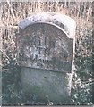
Old Milestone by the A39, Bath Road, north east of Bridgwater
Metal plate attached to stone post by the A39, in parish of Bridgwater Without (Sedgemoor District), near old Bridgwater Cellophane factory, on grass verge, on South East side of road. Bridgwater raised edge, erected by the Bridgwater turnpike trust in the 19th century.
Inscription reads:-
1
Mile
TO
Bridgwater
Somerset HER.
HER number: 17113 https://www.heritagegateway.org.uk/Gateway/Results_Single.aspx?uid=17113&resourceID=100
Milestone Society National ID: SO_BWWL01
Image: © JR Dowding
Taken: 17 Feb 2008
0.22 miles
9
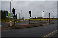
Bridgwater : Bath Road A39
Traffic lights at the crossing on Bath Road.
Image: © Lewis Clarke
Taken: 20 Feb 2016
0.23 miles
10
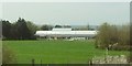
Willowdown Primary Academy
The new school on the northeast edge of Bridgwater, seen from the M5.
Image: © Derek Harper
Taken: 20 Apr 2016
0.24 miles