IMAGES TAKEN NEAR TO
Quantock Terrace, Bristol Road, BRIDGWATER, TA6 4BA
Introduction
This page details the photographs taken nearby to Quantock Terrace, Bristol Road, TA6 4BA by members of the Geograph project.
The Geograph project started in 2005 with the aim of publishing, organising and preserving representative images for every square kilometre of Great Britain, Ireland and the Isle of Man.

There are currently over 7.5m images from over14,400 individuals and you can help contribute to the project by visiting https://www.geograph.org.uk
Image Map (Loading...)


Getting Data...Please wait
Leaflet Map data © OpenStreetMap
Images are licensed for reuse under creativecommons.org/licenses/by-sa/2.0
Notes
- Clicking on the map will re-center to the selected point.
- The higher the marker number, the further away the image location is from the centre of the postcode.
Image Listing (110 Images Found)
Images are licensed for reuse under creativecommons.org/licenses/by-sa/2.0
Image
Details
Distance
1
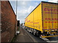
Canute Distribution lorry on the A39, Bridgwater
The articulated lorry is on the A39 The Drove, heading away from the A38 Bristol Road junction.
Canute Distribution is part of the Canute Group whose head office is in Juliette Way, London Road, Purfleet, Essex.
Image: © Jaggery
Taken: 3 Apr 2017
0.05 miles
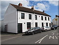
2
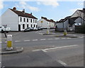
Junction of Bristol Road and Union Street, Bridgwater
Looking towards Union Street from the A38 Bristol Road.
Image: © Jaggery
Taken: 3 Apr 2017
0.05 miles
3
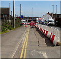
Temporary barrier on the A39 The Drove, Bridgwater
Part of the A39 is blocked off because no left turn is possible ahead.
One carriageway of the A38 Bristol Road is blocked http://www.geograph.org.uk/photo/5340849 by roadworks in early April 2017.
Image: © Jaggery
Taken: 3 Apr 2017
0.05 miles
4
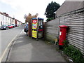
Union Street pillarbox and phonebox, Bridgwater
Near the Bristol Road junction.
Image: © Jaggery
Taken: 3 Apr 2017
0.06 miles
5
Former Volunteer Arms, Union Street, Bridgwater
Viewed in April 2017. The Volunteer Arms was here in Roger Cornfoot's late December 2009 photo. http://www.geograph.org.uk/photo/1636544
Image: © Jaggery
Taken: 3 Apr 2017
0.06 miles
6
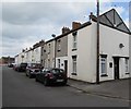
Union Street houses, Bridgwater
Viewed from the edge of these barriers http://www.geograph.org.uk/photo/5351076 looking along Union Street towards Bristol Road.
Image: © Jaggery
Taken: 3 Apr 2017
0.06 miles
7
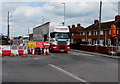
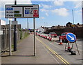
Diversion - road closed - at a major junction in Bridgwater
This is the junction of the A39 The Drove (on the left) and the A38 Bristol Road.
The northbound carriageway of the A38 is blocked by roadworks in early April 2017.
Image: © Jaggery
Taken: 3 Apr 2017
0.06 miles
8
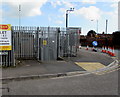
The Drove electricity substation, Bridgwater
The Western Power Distribution electricity substation, identifier
THE DROVE T2539, is on the corner of the A39 The Drove and Boards Road.
Image: © Jaggery
Taken: 3 Apr 2017
0.06 miles
9
A39 directions sign on the approach to the A38 T-junction in Bridgwater
The sign faces eastbound traffic on the A39, here named The Drove.
Image: © Jaggery
Taken: 3 Apr 2017
0.06 miles
10
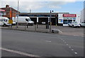
Bridgwater Tyres and Exhausts, Bridgwater
At 130-140 Bristol Road.
Image: © Jaggery
Taken: 3 Apr 2017
0.06 miles