IMAGES TAKEN NEAR TO
The Drove, BRIDGWATER, TA6 4AG
Introduction
This page details the photographs taken nearby to The Drove, TA6 4AG by members of the Geograph project.
The Geograph project started in 2005 with the aim of publishing, organising and preserving representative images for every square kilometre of Great Britain, Ireland and the Isle of Man.

There are currently over 7.5m images from over14,400 individuals and you can help contribute to the project by visiting https://www.geograph.org.uk
Image Map (Loading...)


Getting Data...Please wait
Leaflet Map data © OpenStreetMap
Images are licensed for reuse under creativecommons.org/licenses/by-sa/2.0
Notes
- Clicking on the map will re-center to the selected point.
- The higher the marker number, the further away the image location is from the centre of the postcode.
Image Listing (57 Images Found)
Images are licensed for reuse under creativecommons.org/licenses/by-sa/2.0
Image
Details
Distance
1
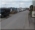
Side road into an industrial estate, Bridgwater
From the north side of the A39. A small circular sign on the left shows a 5mph speed limit.
Image: © Jaggery
Taken: 3 Apr 2017
0.02 miles
2
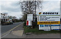
Roberts and K9 information boards, Bridgwater
Facing the A39 on the corner of this http://www.geograph.org.uk/photo/5621301 road into an industrial estate.
Image: © Jaggery
Taken: 3 Apr 2017
0.03 miles
3
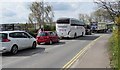
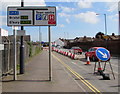
Queueing traffic on the A39, Bridgwater
On the approach to roadworks at the A38 junction viewed in early April 2017.
Image: © Jaggery
Taken: 3 Apr 2017
0.03 miles
4
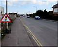
Temporary warning sign facing the A39 The Drove, Bridgwater
The temporary sign warns of temporary traffic lights at roadworks ahead.
Image: © Jaggery
Taken: 3 Apr 2017
0.04 miles
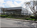
5
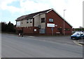
Quantock Veterinary Hospital, The Drove, Bridgwater
On the corner of the A39 The Drove and Quantock Terrace.
Image: © Jaggery
Taken: 3 Apr 2017
0.05 miles
6
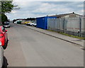
Boards Road, Bridgwater
From the north side of the A39 The Drove, Boards Road is through an industrial area.
Image: © Jaggery
Taken: 3 Apr 2017
0.06 miles
7
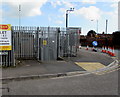
The Drove electricity substation, Bridgwater
The Western Power Distribution electricity substation, identifier
THE DROVE T2539, is on the corner of the A39 The Drove and Boards Road.
Image: © Jaggery
Taken: 3 Apr 2017
0.06 miles
8
A39 directions sign on the approach to the A38 T-junction in Bridgwater
The sign faces eastbound traffic on the A39, here named The Drove.
Image: © Jaggery
Taken: 3 Apr 2017
0.06 miles
9
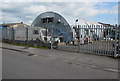
Nissen hut, Boards Road, Bridgwater
Set back from Boards Road near the A39 The Drove junction.
Image: © Jaggery
Taken: 3 Apr 2017
0.06 miles
10
Stacey's Motors Bridgwater
Hyundai dealership viewed across the A39, here named The Drove.
Image: © Jaggery
Taken: 3 Apr 2017
0.06 miles