IMAGES TAKEN NEAR TO
Caradon Place, BRIDGWATER, TA6 3TW
Introduction
This page details the photographs taken nearby to Caradon Place, TA6 3TW by members of the Geograph project.
The Geograph project started in 2005 with the aim of publishing, organising and preserving representative images for every square kilometre of Great Britain, Ireland and the Isle of Man.

There are currently over 7.5m images from over14,400 individuals and you can help contribute to the project by visiting https://www.geograph.org.uk
Image Map
Images are licensed for reuse under creativecommons.org/licenses/by-sa/2.0
Notes
- Clicking on the map will re-center to the selected point.
- The higher the marker number, the further away the image location is from the centre of the postcode.
Image Listing (90 Images Found)
Images are licensed for reuse under creativecommons.org/licenses/by-sa/2.0
Image
Details
Distance
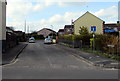
1
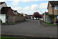
West along Crestfield Avenue, Bridgwater
From the Western Way end of Crestfield Avenue looking in the direction of Carlton Drive.
Image: © Jaggery
Taken: 3 Apr 2017
0.03 miles
2
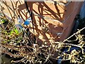
Ordnance Survey Cut Mark
This OS cut mark can be found on No149 Chiltern Street. It marks a point 6.852m above mean sea level.
Image: © Adrian Dust
Taken: 16 Jan 2023
0.04 miles
3
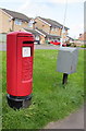
Queen Elizabeth II pillarbox and a Royal Mail drop box in Bridgwater
Alongside Chilton Street near this http://www.geograph.org.uk/photo/5337575 directions sign.
Image: © Jaggery
Taken: 3 Apr 2017
0.05 miles
4
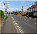
Directions sign facing Chilton Street, Bridgwater
On the southern approach to the A39 Western Way crossroads. G'bury is Glastonbury.
Image: © Jaggery
Taken: 3 Apr 2017
0.05 miles
5
Small gas installation alongside Western Way, Bridgwater
The small green cabinet is a Wales & West Utilities gas installation
located on the grass between Western Way and Crestfield Avenue.
Image: © Jaggery
Taken: 3 Apr 2017
0.06 miles
6
Crestfield Avenue houses, Bridgwater
At the northeast end of Crestfield Avenue, near Western Way.
Image: © Jaggery
Taken: 3 Apr 2017
0.06 miles
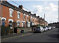
8
Chilton Close, Bridgwater
Cul-de-sac on the west side of Chilton Street.
Image: © Jaggery
Taken: 3 Apr 2017
0.06 miles
9
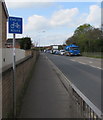
End of cycle route sign, Western Way, Bridgwater
Alongside the A39 Western Way near the Chilton Street crossroads.
The approaching blue lorry is part of the Viridor fleet. http://www.geograph.org.uk/photo/5337512
Image: © Jaggery
Taken: 3 Apr 2017
0.06 miles
10
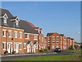
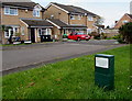
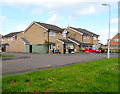
Housing development on the Northern Distributor Road (2005)
Image: © Ken Grainger
Taken: 11 Oct 2008
0.06 miles