IMAGES TAKEN NEAR TO
Riverside Close, BRIDGWATER, TA6 3PP
Introduction
This page details the photographs taken nearby to Riverside Close, TA6 3PP by members of the Geograph project.
The Geograph project started in 2005 with the aim of publishing, organising and preserving representative images for every square kilometre of Great Britain, Ireland and the Isle of Man.

There are currently over 7.5m images from over14,400 individuals and you can help contribute to the project by visiting https://www.geograph.org.uk
Image Map (Loading...)


Getting Data...Please wait
Leaflet Map data © OpenStreetMap
Images are licensed for reuse under creativecommons.org/licenses/by-sa/2.0
Notes
- Clicking on the map will re-center to the selected point.
- The higher the marker number, the further away the image location is from the centre of the postcode.
Image Listing (100 Images Found)
Images are licensed for reuse under creativecommons.org/licenses/by-sa/2.0
Image
Details
Distance
1
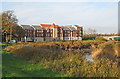
Trinity Gate, Bridgwater
Housing development 2007, and the River Parrett.
Image: © Ken Grainger
Taken: 12 Nov 2008
0.02 miles
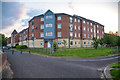
2
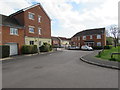
Southeast side of Riverside Close, Bridgwater
Riverside Close is between the A39 Western Way and the River Parrett.
Image: © Jaggery
Taken: 3 Apr 2017
0.02 miles
3
Path from Linham Road to Western Way, Bridgwater
The path is a combined cycleway and footpath.
Nearby metal posts http://www.geograph.org.uk/photo/5448698 prevent motor vehicle misuse of the path.
Image: © Jaggery
Taken: 3 Apr 2017
0.03 miles
4
End of cycle route sign, Western Way, Bridgwater
On the approach to the bridge carrying the A39 Western Way over the River Parrett.
Image: © Jaggery
Taken: 3 Apr 2017
0.03 miles
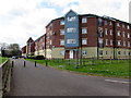
5
Bridgwater : Flats
Flats on Riverside Close.
Image: © Lewis Clarke
Taken: 22 May 2018
0.04 miles
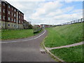
6
Linham Road flats, Bridgwater
On a bank of the River Parrett.
Image: © Jaggery
Taken: 3 Apr 2017
0.04 miles
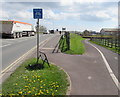
7

England Coast Path signpost, Bridgwater
On the north side of Western Way near the corner of Standish Street.
Image: © Jaggery
Taken: 3 Apr 2017
0.04 miles
8
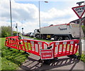
Western Way footpath closed, Bridgwater
On April 3rd 2017 temporary barriers block access to the Western Way pavement from Standish Street.
Image: © Jaggery
Taken: 3 Apr 2017
0.04 miles
9
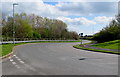
Road to the Household Waste Recycling Centre, Bridgwater
From Standish Street near Western Way.
Image: © Jaggery
Taken: 3 Apr 2017
0.05 miles
10
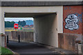
Bridgwater : Footpath
A footpath underneath the A39 road.
Image: © Lewis Clarke
Taken: 22 May 2018
0.06 miles