IMAGES TAKEN NEAR TO
Saltlands, BRIDGWATER, TA6 3JQ
Introduction
This page details the photographs taken nearby to Saltlands, TA6 3JQ by members of the Geograph project.
The Geograph project started in 2005 with the aim of publishing, organising and preserving representative images for every square kilometre of Great Britain, Ireland and the Isle of Man.

There are currently over 7.5m images from over14,400 individuals and you can help contribute to the project by visiting https://www.geograph.org.uk
Image Map (Loading...)


Getting Data...Please wait
Leaflet Map data © OpenStreetMap
Images are licensed for reuse under creativecommons.org/licenses/by-sa/2.0
Notes
- Clicking on the map will re-center to the selected point.
- The higher the marker number, the further away the image location is from the centre of the postcode.
Image Listing (110 Images Found)
Images are licensed for reuse under creativecommons.org/licenses/by-sa/2.0
Image
Details
Distance
1
Saltlands, Bridgwater
Saltlands is a cul-de-sac on the north side of Saltlands Avenue, about 150 metres west of the River Parrett.
Image: © Jaggery
Taken: 3 Apr 2017
0.01 miles
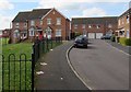
2
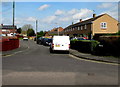
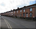
Long row of houses, Saltlands Avenue, Bridgwater
Extending for 45 metres from the corner of Chilton Street on the left to the Saltlands junction on the right.
Image: © Jaggery
Taken: 3 Apr 2017
0.04 miles
3
Bridgwater : Saltlands House
Looking towards Saltlands House in Bridgwater.
Image: © Lewis Clarke
Taken: 22 May 2018
0.04 miles
4
Bridgwater : Saltlands Avenue
Looking along Saltlands Avenue in Bridgwater.
Image: © Lewis Clarke
Taken: 22 May 2018
0.04 miles
5
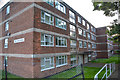
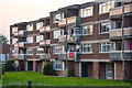
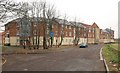
Bridgwater : Saltlands House
A block of flats in Bridgwater.
Image: © Lewis Clarke
Taken: 22 May 2018
0.05 miles
6
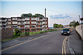
West side of Riverside Close, Bridgwater
Riverside Close is between the A39 Western Way and the River Parrett.
Image: © Jaggery
Taken: 3 Apr 2017
0.06 miles
8
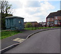
Western Power Distribution electricity substation, Riverside Close, Bridgwater
The Western Power Distribution electricity substation identifier is N D R EAST 218607.
Riverside Close is between the A39 Western Way and the River Parrett.
Image: © Jaggery
Taken: 3 Apr 2017
0.06 miles
9
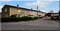
Long row of houses on the west side of Chilton Street, Bridgwater
Extending from the corner of Chilton Close towards Crowpill Lane.
Image: © Jaggery
Taken: 3 Apr 2017
0.06 miles
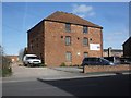
10
New flats, Trinity Gate, Bridgwater
A closer view of the flats by the Parrett shown in Image These are on Riverside Close, and seen from Linham Road.
Image: © Derek Harper
Taken: 15 Feb 2010
0.06 miles