IMAGES TAKEN NEAR TO
Riverside, BRIDGWATER, TA6 3JJ
Introduction
This page details the photographs taken nearby to Riverside, TA6 3JJ by members of the Geograph project.
The Geograph project started in 2005 with the aim of publishing, organising and preserving representative images for every square kilometre of Great Britain, Ireland and the Isle of Man.

There are currently over 7.5m images from over14,400 individuals and you can help contribute to the project by visiting https://www.geograph.org.uk
Image Map (Loading...)


Getting Data...Please wait
Leaflet Map data © OpenStreetMap
Images are licensed for reuse under creativecommons.org/licenses/by-sa/2.0
Notes
- Clicking on the map will re-center to the selected point.
- The higher the marker number, the further away the image location is from the centre of the postcode.
Image Listing (195 Images Found)
Images are licensed for reuse under creativecommons.org/licenses/by-sa/2.0
Image
Details
Distance
1
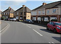
Change of house type, Chilton Street, Bridgwater
At a bend on the east side of the street.
Image: © Jaggery
Taken: 3 Apr 2017
0.03 miles
2
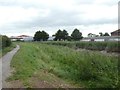
Footpath and reeds by River Parrett, Bridgwater
Image: © David Smith
Taken: 5 Aug 2020
0.04 miles
3
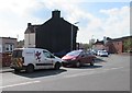
Somerset Highways van in Bridgwater
Displaying the traditional red dragon emblem of Somerset, the highway
maintenance van is parked at the southern end of Chilton Street.
Image: © Jaggery
Taken: 3 Apr 2017
0.04 miles
4
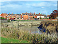
The River Parrett at Bridgwater
Flowing north out of the town towards the Bristol Channel, past flood defence walls.
Image: © Ken Grainger
Taken: 19 Nov 2007
0.05 miles
5
Chilton Street electricity substation, Bridgwater
The Western Power Distribution electricity substation is in a wooden enclosure set back from Chilton Street near the corner of Kendale Road. Its identifier is CHILTON STREET B1024.
Image: © Jaggery
Taken: 3 Apr 2017
0.05 miles
6
Unnamed side road in the north of Bridgwater
On the northwest side of the corner of Chilton Street and Kendale Road.
Chilton Street electricity substation http://www.geograph.org.uk/photo/5339164 is in the wooden enclosure on the right.
Image: © Jaggery
Taken: 3 Apr 2017
0.06 miles
7
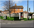
Communications enablers on a Bridgwater corner
A BT phonebox and a Virgin Media telecoms cabinet are on the corner of Chilton Street and Waverley Road.
Image: © Jaggery
Taken: 3 Apr 2017
0.06 miles
8
Kendale Road pedestrian refuge, Bridgwater
At the eastern end of Kendale Road, near the Chilton Street junction.
Image: © Jaggery
Taken: 3 Apr 2017
0.06 miles
9
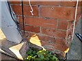
Ordnance Survey Cut Mark
This OS cut mark can be found on No240 Kendale Road. It marks a point 8.239m above mean sea level.
Image: © Adrian Dust
Taken: 16 Jan 2023
0.06 miles
10
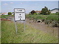
Mind your head!
A height warning for marine traffic on the River Parrett, not unlike road signs.
Image: © Neil Owen
Taken: 17 Jun 2014
0.07 miles