IMAGES TAKEN NEAR TO
Burnish Grove, TA5 2SY
Introduction
This page details the photographs taken nearby to Burnish Grove, TA5 2SY by members of the Geograph project.
The Geograph project started in 2005 with the aim of publishing, organising and preserving representative images for every square kilometre of Great Britain, Ireland and the Isle of Man.

There are currently over 7.5m images from over14,400 individuals and you can help contribute to the project by visiting https://www.geograph.org.uk
Image Map (Loading...)


Getting Data...Please wait
Leaflet Map data © OpenStreetMap
Images are licensed for reuse under creativecommons.org/licenses/by-sa/2.0
Notes
- Clicking on the map will re-center to the selected point.
- The higher the marker number, the further away the image location is from the centre of the postcode.
Image Listing (13 Images Found)
Images are licensed for reuse under creativecommons.org/licenses/by-sa/2.0
Image
Details
Distance
1
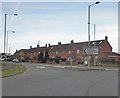
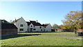
Terraced houses on Main Road, Cannington
Image: © Roger Cornfoot
Taken: 1 Apr 2015
0.11 miles
3
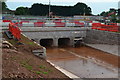
New drainage culvert under the A39
Had the temporary closure notice been well-signed at the other end of the footpath, we would not have been viewing it from this side!
Image: © David Martin
Taken: 28 May 2017
0.16 miles
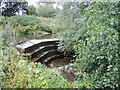
4
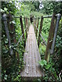
Footbridge near Otters Brook
The bridge spans the Cannington Brook - Otters Brook is the name given to a modern housing development.
Image: © Neil Owen
Taken: 19 Aug 2021
0.18 miles
5
Weir on Cannington Brook
The waters around the village are many and convoluted, needing a weir to the east.
Image: © Neil Owen
Taken: 19 Aug 2021
0.19 miles
6
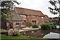
Gurney Manor Mill
A watermill which has been tastefully converted into a home and bed and breakfast accommodation.
Image: © Paul Buckingham
Taken: 19 Sep 2009
0.20 miles
7
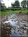
Seeping down from the higher level
The waters near Gurney Manor are complicated, with two levels opposite the ancient manor house. Here the higher bank appears to be allowing some seepage across the ground to the lower.
Image: © Neil Owen
Taken: 19 Aug 2021
0.20 miles
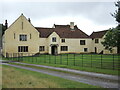
8
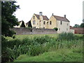
Gurney Manor
There are records of a house here in the thirteenth century, which is no longer standing. The present structure dates from around 1400, with several changes and alterations in its long history. The estate was known to be the property of John de Gurney and the house is known in his name, although that family disappears from records by the fifteenth century.
Image: © Neil Owen
Taken: 19 Aug 2021
0.21 miles
10
Staying at the old house
Gurney Manor is a Grade I listed manor house dating from the 1300s. In its time it will have seen many visitors but since the 1940s it has been subdivided into separate apartments. Today it is a holiday let, run by the Landmark Trust.
Image: © Neil Owen
Taken: 19 Aug 2021
0.23 miles