IMAGES TAKEN NEAR TO
Otters Brook, BRIDGWATER, TA5 2NT
Introduction
This page details the photographs taken nearby to Otters Brook, TA5 2NT by members of the Geograph project.
The Geograph project started in 2005 with the aim of publishing, organising and preserving representative images for every square kilometre of Great Britain, Ireland and the Isle of Man.

There are currently over 7.5m images from over14,400 individuals and you can help contribute to the project by visiting https://www.geograph.org.uk
Image Map (Loading...)


Getting Data...Please wait
Leaflet Map data © OpenStreetMap
Images are licensed for reuse under creativecommons.org/licenses/by-sa/2.0
Notes
- Clicking on the map will re-center to the selected point.
- The higher the marker number, the further away the image location is from the centre of the postcode.
Image Listing (145 Images Found)
Images are licensed for reuse under creativecommons.org/licenses/by-sa/2.0
Image
Details
Distance
1
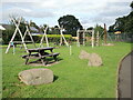
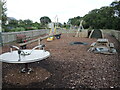
Adventures and picnics
The Brook Street play area features some sturdy wooden climbing frames, with a picnic table for the parents.
Image: © Neil Owen
Taken: 19 Aug 2021
0.07 miles
2
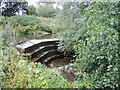
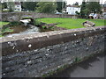
Weir on Cannington Brook
The waters around the village are many and convoluted, needing a weir to the east.
Image: © Neil Owen
Taken: 19 Aug 2021
0.08 miles
3
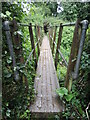
Footbridge near Otters Brook
The bridge spans the Cannington Brook - Otters Brook is the name given to a modern housing development.
Image: © Neil Owen
Taken: 19 Aug 2021
0.08 miles
4
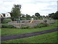
Brook Street Play Area
A safe and secure area for the little ones, it was completely rebuilt in late 2015. It includes new euqipment, a zip wire and a hard sports court. Funding came partly from the Hinckley C power station organisation.
Image: © Neil Owen
Taken: 19 Aug 2021
0.10 miles
5
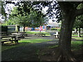
Tunnels, tables and turntables
New play equipment, with wood bark flooring to absorb impacts.
Image: © Neil Owen
Taken: 19 Aug 2021
0.10 miles
7
Cannington primary school
Schooling in Cannington began properly in the 1850s and carries on today at the same site.
Image: © Neil Owen
Taken: 19 Aug 2021
0.12 miles
8
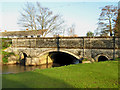
Cannington Bridge
This 1929 bridge across the Cannington Brook, also shown in Image, would have enabled the narrow Brook Bridge, less than 30 metres upstream to the left, to be avoided.
Image: © Derek Harper
Taken: 16 Apr 2011
0.12 miles
9
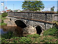
Cannington Bridge
As is the case with the old Somerset County Council, the road over the brook has its name carved into the stonework. The road is a relatively new route, being roughly a century old.
Image: © Neil Owen
Taken: 19 Aug 2021
0.12 miles
10
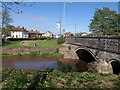
Cannington Bridge
The bridge carries the main road through the village across the Cannington Brook, and dates from 1929.
Image: © Derek Harper
Taken: 16 Apr 2011
0.13 miles