IMAGES TAKEN NEAR TO
Cannington, BRIDGWATER, TA5 2LD
Introduction
This page details the photographs taken nearby to TA5 2LD by members of the Geograph project.
The Geograph project started in 2005 with the aim of publishing, organising and preserving representative images for every square kilometre of Great Britain, Ireland and the Isle of Man.

There are currently over 7.5m images from over14,400 individuals and you can help contribute to the project by visiting https://www.geograph.org.uk
Image Map
Images are licensed for reuse under creativecommons.org/licenses/by-sa/2.0
Notes
- Clicking on the map will re-center to the selected point.
- The higher the marker number, the further away the image location is from the centre of the postcode.
Image Listing (5 Images Found)
Images are licensed for reuse under creativecommons.org/licenses/by-sa/2.0
Image
Details
Distance
1
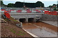
New drainage culvert under the A39
Had the temporary closure notice been well-signed at the other end of the footpath, we would not have been viewing it from this side!
Image: © David Martin
Taken: 28 May 2017
0.07 miles
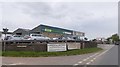
2
Bridgwater Mowers on the edge of Cannington
Image: © David Smith
Taken: 14 Apr 2011
0.11 miles
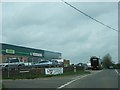
3
Bridgwater Mowers by A39 south of Cannington
Image: © David Smith
Taken: 11 May 2018
0.12 miles
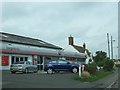
4
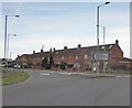
Terraced houses on Main Road, Cannington
Image: © Roger Cornfoot
Taken: 1 Apr 2015
0.14 miles