IMAGES TAKEN NEAR TO
Enmore, BRIDGWATER, TA5 2DX
Introduction
This page details the photographs taken nearby to TA5 2DX by members of the Geograph project.
The Geograph project started in 2005 with the aim of publishing, organising and preserving representative images for every square kilometre of Great Britain, Ireland and the Isle of Man.

There are currently over 7.5m images from over14,400 individuals and you can help contribute to the project by visiting https://www.geograph.org.uk
Image Map (Loading...)


Getting Data...Please wait
Leaflet Map data © OpenStreetMap
Images are licensed for reuse under creativecommons.org/licenses/by-sa/2.0
Notes
- Clicking on the map will re-center to the selected point.
- The higher the marker number, the further away the image location is from the centre of the postcode.
Image Listing (15 Images Found)
Images are licensed for reuse under creativecommons.org/licenses/by-sa/2.0
Image
Details
Distance
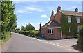
1
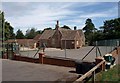
Enmore Primary School
Another view of Image According to the listed building description, this is thought to have been the first Free National School in England when it was founded in 1810. The present building dates from the mid-C19. http://webapp1.somerset.gov.uk/her/details.asp?prn=13554
Image: © Derek Harper
Taken: 26 Jul 2010
0.01 miles
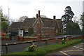
3
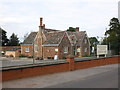
Enmore Church of England Primary School
Image: © nick macneill
Taken: 14 Mar 2013
0.01 miles
4
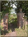
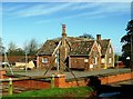
Start of bridleway, Enmore
These brick and tone gatepiers with ball finials make a grand opening for bridleway BW15/15 from Enmore Road http://www.britishlistedbuildings.co.uk/en-269289-roadside-gateway-adjacent-to-east-side-o . This is part of the landscape park of Enmore Castle. The former lodge, the cottage in the background, is now an Animal Rescue Centre.
Image: © Derek Harper
Taken: 26 Jul 2010
0.02 miles
5
Road junction, Enmore
Image is on the left at this point. The house is mapped as "Sawmills"; according to http://www.british-history.ac.uk/report.aspx?compid=18524 , there was a sawmill at Enmore in the early C20. Was it here?
The main road is the old turnpike to Bridgwater; the right turn is for Lydeard Cross, up on the Quantocks.
Image: © Derek Harper
Taken: 26 Jul 2010
0.02 miles
6
Enmore Church of England Primary School
Image: © Adrian and Janet Quantock
Taken: 23 Apr 2006
0.03 miles
7
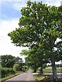
Enmore Road
Seen from close to Image, whose car park is on the right. Oaks line the former turnpike road up onto the Quantocks.
Image: © Derek Harper
Taken: 26 Jul 2010
0.06 miles
8
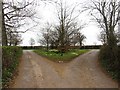
A road junction, Enmore
The small road triangle is now well stocked with trees.
Image: © Richard Webb
Taken: 31 Mar 2012
0.08 miles