IMAGES TAKEN NEAR TO
Enmore, BRIDGWATER, TA5 2DU
Introduction
This page details the photographs taken nearby to TA5 2DU by members of the Geograph project.
The Geograph project started in 2005 with the aim of publishing, organising and preserving representative images for every square kilometre of Great Britain, Ireland and the Isle of Man.

There are currently over 7.5m images from over14,400 individuals and you can help contribute to the project by visiting https://www.geograph.org.uk
Image Map (Loading...)


Getting Data...Please wait
Leaflet Map data © OpenStreetMap
Images are licensed for reuse under creativecommons.org/licenses/by-sa/2.0
Notes
- Clicking on the map will re-center to the selected point.
- The higher the marker number, the further away the image location is from the centre of the postcode.
Image Listing (39 Images Found)
Images are licensed for reuse under creativecommons.org/licenses/by-sa/2.0
Image
Details
Distance
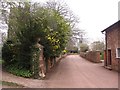
2
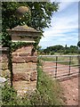
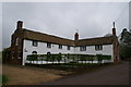
Gatepier, Enmore
A closer view of the gate pier shown in Image, described as a "rusticated brick and stone pier, moulded stone" cap with ball finial http://webapp1.somerset.gov.uk/her/details.asp?prn=13547 . The view beyond is across the golf course.
Image: © Derek Harper
Taken: 26 Jul 2010
0.02 miles
3
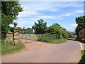
Gateway, Enmore
On the right is the stretch of lane shown in Image The gate pier with its ball finial on the left marks the eastern end of the (probably C18) wall bounding the churchyard http://webapp1.somerset.gov.uk/her/details.asp?prn=13547 .
Image: © Derek Harper
Taken: 26 Jul 2010
0.02 miles
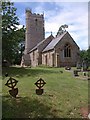
6
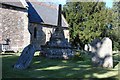
St. Michael's Churchyard, Cross
Scheduled Ancient Monument, 15th Century.
Image: © Andrew Riley
Taken: 21 Mar 2007
0.03 miles
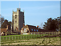
7
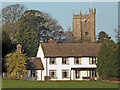
Enmore village
And the c14 church of St Michael.
Image: © Ken Grainger
Taken: 7 Dec 2008
0.04 miles
8
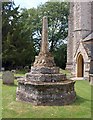
Churchyard cross, Enmore
A view of Image from the other direction. Each of the four sides of the socket carries three shields http://www.britishlistedbuildings.co.uk/en-269280-churchyard-cross-in-churchyard-church-of . On the right is Image
Image: © Derek Harper
Taken: 26 Jul 2010
0.04 miles
9
Enmore
The pink road is due to soil dust, ie ex- and future mud. The Quantock Hills are made of old red sandstone and have red soils.
Image: © Richard Webb
Taken: 31 Mar 2012
0.05 miles
10
St Michael's Church, Enmore
The churchyard extends over an easting gridline. This view of Image is taken looking across it. http://webapp1.somerset.gov.uk/her/details.asp?prn=13541
Image: © Derek Harper
Taken: 26 Jul 2010
0.05 miles