IMAGES TAKEN NEAR TO
Wembdon, BRIDGWATER, TA5 2BD
Introduction
This page details the photographs taken nearby to TA5 2BD by members of the Geograph project.
The Geograph project started in 2005 with the aim of publishing, organising and preserving representative images for every square kilometre of Great Britain, Ireland and the Isle of Man.

There are currently over 7.5m images from over14,400 individuals and you can help contribute to the project by visiting https://www.geograph.org.uk
Image Map (Loading...)


Getting Data...Please wait
Leaflet Map data © OpenStreetMap
Images are licensed for reuse under creativecommons.org/licenses/by-sa/2.0
Notes
- Clicking on the map will re-center to the selected point.
- The higher the marker number, the further away the image location is from the centre of the postcode.
Image Listing (11 Images Found)
Images are licensed for reuse under creativecommons.org/licenses/by-sa/2.0
Image
Details
Distance
2

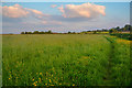
Sedgemoor : Grassy Field
A grassy field with the sun setting in the distance.
Image: © Lewis Clarke
Taken: 22 May 2018
0.17 miles
3
Sedgemoor : Grassy Field
A grassy field with a right of way heading through.
Image: © Lewis Clarke
Taken: 22 May 2018
0.18 miles
5
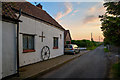
Sedgemoor : Blakes Lane
Looking along Blakes Lane in Sedgemoor.
Image: © Lewis Clarke
Taken: 22 May 2018
0.20 miles
6
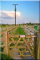
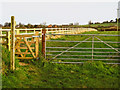
Sedgemoor : Grassy Footpath
Looking along a grassy footpath between paddocks.
Image: © Lewis Clarke
Taken: 22 May 2018
0.21 miles
7
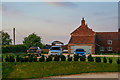
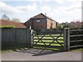
Sedgemoor : Grabhams Farm
Looking towards Grabhams Farm.
Image: © Lewis Clarke
Taken: 22 May 2018
0.23 miles
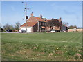
9
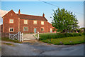
Sedgemoor : Grabhams Farm
Looking towards Grabhams Farm in Sedgemoor.
Image: © Lewis Clarke
Taken: 22 May 2018
0.24 miles
10
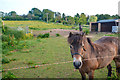
Sedgemoor : Grassy Field & Horses
Horses in a field off of Blakes Lane.
Image: © Lewis Clarke
Taken: 22 May 2018
0.24 miles