IMAGES TAKEN NEAR TO
Kilve, BRIDGWATER, TA5 1SS
Introduction
This page details the photographs taken nearby to TA5 1SS by members of the Geograph project.
The Geograph project started in 2005 with the aim of publishing, organising and preserving representative images for every square kilometre of Great Britain, Ireland and the Isle of Man.

There are currently over 7.5m images from over14,400 individuals and you can help contribute to the project by visiting https://www.geograph.org.uk
Image Map (Loading...)


Getting Data...Please wait
Leaflet Map data © OpenStreetMap
Images are licensed for reuse under creativecommons.org/licenses/by-sa/2.0
Notes
- Clicking on the map will re-center to the selected point.
- The higher the marker number, the further away the image location is from the centre of the postcode.
Image Listing (12 Images Found)
Images are licensed for reuse under creativecommons.org/licenses/by-sa/2.0
Image
Details
Distance
2
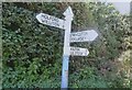
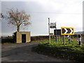
Old Direction Sign - Signpost north of Kilton Cross
Pyramid finial - 3 arms; Somerset SCC pyramid by the UC road, in parish of Kilve (West Somerset District), junction of lanes North of Kilton Cross.
Surveyed
Milestone Society National ID: SO_ST1542
Image: © Milestone Society
Taken: Unknown
0.09 miles
3
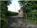
Holford Telephone Exchange (1)
Situated just North of Kilton Cross, this TE provides telephone and broadband services to 385 residential and 28 non-residential premises in Holford plus East Quantoxhead, Kilton, Kilve, Lilstock and Stringston nearby. The drainpipe, entrance door and combination lock can be seen in this photo. The numbering range of this TE is (01278) 741xxx, the (01278) referring to the Bridgwater group of thirteen TEs, and its postcode is TA5 1SS.
Image: © David Hillas
Taken: 29 Sep 2011
0.09 miles
4
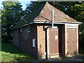
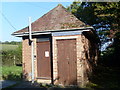
Holford Telephone Exchange (2)
This TE, which has the code WWHOLF, appears to date from the GPO era, but has been extended at the back more recently presumably to meet the present digital era. On the side of the building can be seen two ventilation louvres and a white cupboard which presumably holds the electricity meter. An electric cable can be seen leading from the TE to the left of the photo.
Image: © David Hillas
Taken: 29 Sep 2011
0.09 miles
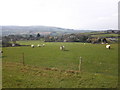
6
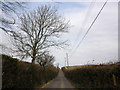
Minor crossroads, on the A39, between Kilve and Holford
Image: © Roger Cornfoot
Taken: 3 Dec 2010
0.19 miles
8
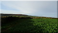
View W along field path, Waltham's Copse near Kilve
Image: © Colin Park
Taken: 4 Dec 2018
0.19 miles
10
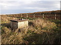
Observation Post above Kilve
A Royal Observer Corps underground monitoring post, now disused.
Image: © Chris Andrews
Taken: 25 Nov 2012
0.21 miles