IMAGES TAKEN NEAR TO
Holford, BRIDGWATER, TA5 1SF
Introduction
This page details the photographs taken nearby to TA5 1SF by members of the Geograph project.
The Geograph project started in 2005 with the aim of publishing, organising and preserving representative images for every square kilometre of Great Britain, Ireland and the Isle of Man.

There are currently over 7.5m images from over14,400 individuals and you can help contribute to the project by visiting https://www.geograph.org.uk
Image Map (Loading...)


Getting Data...Please wait
Leaflet Map data © OpenStreetMap
Images are licensed for reuse under creativecommons.org/licenses/by-sa/2.0
Notes
- Clicking on the map will re-center to the selected point.
- The higher the marker number, the further away the image location is from the centre of the postcode.
Image Listing (6 Images Found)
Images are licensed for reuse under creativecommons.org/licenses/by-sa/2.0
Image
Details
Distance
2
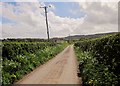
Portway Lane
See Image]; this is the southern arm of the lane, leading to Dyche; Dyche Farm can be seen ahead past the wonky telegraph pole. On the horizon are the Quantocks.
Image: © Derek Harper
Taken: 26 Apr 2014
0.11 miles
3
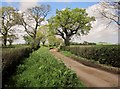
Lane to Dyche
Portway Lane passes oak trees and crosses Bayley's Brook, which here forms also the parish boundary between Holford and Stringston.
Image: © Derek Harper
Taken: 26 Apr 2014
0.16 miles
4
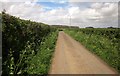
Portway Lane north of Dyche
Up ahead is the junction with ... Portway Lane. According to the maps, the three lanes from the junction are all called Portway Lane. Ahead on the rising ground is Ten Acre Copse.
Image: © Derek Harper
Taken: 26 Apr 2014
0.18 miles
5
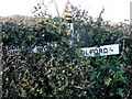
SCC finger-post at Portway Lane
The finger pointing towards the camera, and Stringston, is missing and the rest of the signpost is being subsumed into the hedge.
Image: © Jonathan Billinger
Taken: 17 Dec 2009
0.21 miles
6
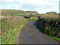
Portway Lane
The road heads west towards Holford from the bend in this shot.
The woodland in winter guise is on the high ground to the north-west of Stringston.
Image: © Jonathan Billinger
Taken: 17 Dec 2009
0.25 miles