IMAGES TAKEN NEAR TO
Holford, BRIDGWATER, TA5 1RZ
Introduction
This page details the photographs taken nearby to TA5 1RZ by members of the Geograph project.
The Geograph project started in 2005 with the aim of publishing, organising and preserving representative images for every square kilometre of Great Britain, Ireland and the Isle of Man.

There are currently over 7.5m images from over14,400 individuals and you can help contribute to the project by visiting https://www.geograph.org.uk
Image Map
Images are licensed for reuse under creativecommons.org/licenses/by-sa/2.0
Notes
- Clicking on the map will re-center to the selected point.
- The higher the marker number, the further away the image location is from the centre of the postcode.
Image Listing (44 Images Found)
Images are licensed for reuse under creativecommons.org/licenses/by-sa/2.0
Image
Details
Distance
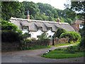
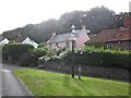
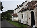
1
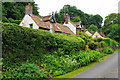
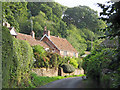
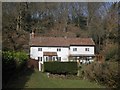
Cottages in Holford Combe
Well hidden behind big hedges. The village of Holford extends in a straggly line up the floor of the combe.
Image: © Bill Boaden
Taken: 26 Jun 2017
0.00 miles
4
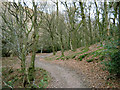
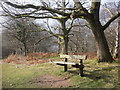
Hodder's Combe
The path winding into Holford.
Image: © Ken Grainger
Taken: 20 Nov 2008
0.07 miles