IMAGES TAKEN NEAR TO
Holford, BRIDGWATER, TA5 1RY
Introduction
This page details the photographs taken nearby to TA5 1RY by members of the Geograph project.
The Geograph project started in 2005 with the aim of publishing, organising and preserving representative images for every square kilometre of Great Britain, Ireland and the Isle of Man.

There are currently over 7.5m images from over14,400 individuals and you can help contribute to the project by visiting https://www.geograph.org.uk
Image Map (Loading...)


Getting Data...Please wait
Leaflet Map data © OpenStreetMap
Images are licensed for reuse under creativecommons.org/licenses/by-sa/2.0
Notes
- Clicking on the map will re-center to the selected point.
- The higher the marker number, the further away the image location is from the centre of the postcode.
Image Listing (44 Images Found)
Images are licensed for reuse under creativecommons.org/licenses/by-sa/2.0
Image
Details
Distance
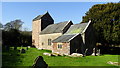
2
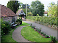
St Mary's Church, Holford
The church gate and garden
Image: © Ken Grainger
Taken: 4 Sep 2010
0.05 miles
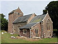
4
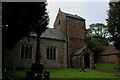
Church of St. Mary the Virgin, Holford
19th Century building, constructed on the site of an earlier 12th Century church.
Grade II Listed, with a rather unusual tower.
Image: © Chris Heaton
Taken: 11 Jun 2021
0.06 miles
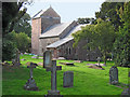
7
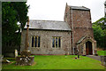
St Mary the Virgin, Holford
A large yew by the entrance path prevents a better view of the church. The church belongs to the Quantock Coast Benefice, which comprises the parishes of Stogursey and Stolford, Fiddington, Dodington, East Quantoxhead, Holford, Kilve with Kilton and Lilstock, Stringston, West Quantoxhead. Quite a big job for the Rector.
Image: © Bill Boaden
Taken: 26 Jun 2017
0.06 miles
9
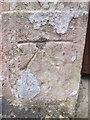
Ordnance Survey 1GL Bolt
This OS Bolt can be found on the porch of St Mary's Church. It marks a point 117.657m above mean sea level.
Image: © Adrian Dust
Taken: 18 May 2015
0.06 miles
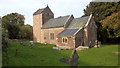
10
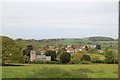
Holford Church
Holford village beyond the church.
Image: © Clive Perrin
Taken: 17 May 2012
0.07 miles