IMAGES TAKEN NEAR TO
Fairfield Drive, BRIDGWATER, TA5 1PX
Introduction
This page details the photographs taken nearby to Fairfield Drive, TA5 1PX by members of the Geograph project.
The Geograph project started in 2005 with the aim of publishing, organising and preserving representative images for every square kilometre of Great Britain, Ireland and the Isle of Man.

There are currently over 7.5m images from over14,400 individuals and you can help contribute to the project by visiting https://www.geograph.org.uk
Image Map
Images are licensed for reuse under creativecommons.org/licenses/by-sa/2.0
Notes
- Clicking on the map will re-center to the selected point.
- The higher the marker number, the further away the image location is from the centre of the postcode.
Image Listing (4 Images Found)
Images are licensed for reuse under creativecommons.org/licenses/by-sa/2.0
Image
Details
Distance
2
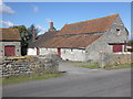
Junction at Water Farm
With Image on the left, and seen from the road from Stringston. Left at the T-junction for Burton, and right for Stogursey.
Image: © Derek Harper
Taken: 26 Apr 2014
0.23 miles
3
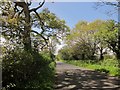
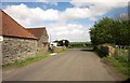
Road to Stringston
From Stogursey, and running between freshly-leaved trees down a straight stretch.
Image: © Derek Harper
Taken: 26 Apr 2014
0.24 miles
4
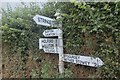
Old Direction Sign - Signpost west of Stogursey
Pyramid finial - 5 arms; Somerset SCC pyramid by the UC road, in parish of Stogursey (West Somerset District), junction of Tower Hill and lane to Stringston, near Water Farm.
Surveyed
Milestone Society National ID: SO_ST1943C.
Image: © Milestone Society
Taken: Unknown
0.24 miles