IMAGES TAKEN NEAR TO
Banneson Road, BRIDGWATER, TA5 1NW
Introduction
This page details the photographs taken nearby to Banneson Road, TA5 1NW by members of the Geograph project.
The Geograph project started in 2005 with the aim of publishing, organising and preserving representative images for every square kilometre of Great Britain, Ireland and the Isle of Man.

There are currently over 7.5m images from over14,400 individuals and you can help contribute to the project by visiting https://www.geograph.org.uk
Image Map (Loading...)


Getting Data...Please wait
Leaflet Map data © OpenStreetMap
Images are licensed for reuse under creativecommons.org/licenses/by-sa/2.0
Notes
- Clicking on the map will re-center to the selected point.
- The higher the marker number, the further away the image location is from the centre of the postcode.
Image Listing (69 Images Found)
Images are licensed for reuse under creativecommons.org/licenses/by-sa/2.0
Image
Details
Distance
1
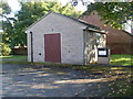
Nether Stowey Telephone Exchange (2)
Across the parking area from the TE in Banneson Road, this building would appear to be the generating station for that TE. The white notice on the small stone column says the following:
Diesel Fuel Oil Class A Only
Fill and Sludge Suction Point
Tank No
Tank Capacity 1050 Gallons
Tank Capacity 4767 Litres
Image: © David Hillas
Taken: 29 Sep 2011
0.03 miles
2
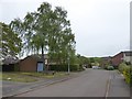
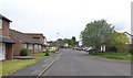
Oak Road, Nether Stowey
Part of a housing estate south of the old centre of the village
Image: © David Smith
Taken: 11 May 2018
0.04 miles
3
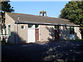
Nether Stowey Telephone Exchange (1)
Situated in Banneson Road, this TE would appear to date from the 1980s and serves Nether Stowey plus Burton, Fiddington, Keenthorne, Over Stowey, Shurton and Stogursey nearby. The tower behind the TE is part of the adjacent fire station. The numbering range of this TE is (01278) 732xxx, 733xxx, the (01278) referring to the Bridgwater group of TEs, and its postcode is TA5 1NW.
Image: © David Hillas
Taken: 29 Sep 2011
0.05 miles
4
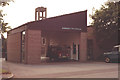
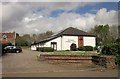
Nether Stowey Fire Station
Nether Stowey Fire Station, Banneson Road, Nether Stowey, Somerset.
Image: © Kevin Hale
Taken: 15 Jul 1990
0.08 miles
5
Old Farm Road, Nether Stowey
Part of a housing estate - presumably where there was once farmland
Image: © David Smith
Taken: 11 May 2018
0.08 miles
6
The Old Toll House: Nether Stowey
This old toll house is situated on the A39 that passes through the centre of the town and is in the north western section of the grid square. This picture was taken from the other side of the road which is very narrow and very busy.
Image: © Pam Brophy
Taken: Unknown
0.08 miles
7
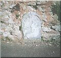
Old Boundary Marker on St Mary Street
Turnpike Terminus Marker set into the foot of the garden wall of The Old Vicarage facing onto the north side of St Mary Street. Nether Stowey parish. Inscribed HERE / ENDS / BRIDGEWATER / ROAD.
Milestone Society National ID: SO_BRtXt
Image: © J Dowding
Taken: 13 Mar 2005
0.09 miles
8
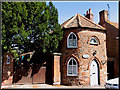
Nether Stowey Church Centre
St Mary's Church Centre is on St Mary's Street at the east end of the village. On the left is the Vicarage.
Image: © Derek Harper
Taken: 26 Apr 2014
0.09 miles
9
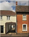
Houses in Nether Stowey
A passageway beneath the first floor of a house on St Mary's Street. The house on the right is Scotts http://list.english-heritage.org.uk/resultsingle.aspx?uid=1237410&searchtype=mapsearch , with one of "12-pane sash windows in moulded stone architraves with keyed cambered heads".
Image: © Derek Harper
Taken: 26 Apr 2014
0.10 miles
10
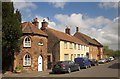
St Mary's Street, Nether Stowey
On the left is the C18 former toll house https://historicengland.org.uk/listing/the-list/list-entry/1059044 , shown in Image At the other end of the terrace is Scott's https://historicengland.org.uk/listing/the-list/list-entry/1237410 .
Image: © Derek Harper
Taken: 26 Apr 2014
0.10 miles