IMAGES TAKEN NEAR TO
Nether Stowey, BRIDGWATER, TA5 1LT
Introduction
This page details the photographs taken nearby to TA5 1LT by members of the Geograph project.
The Geograph project started in 2005 with the aim of publishing, organising and preserving representative images for every square kilometre of Great Britain, Ireland and the Isle of Man.

There are currently over 7.5m images from over14,400 individuals and you can help contribute to the project by visiting https://www.geograph.org.uk
Image Map
Images are licensed for reuse under creativecommons.org/licenses/by-sa/2.0
Notes
- Clicking on the map will re-center to the selected point.
- The higher the marker number, the further away the image location is from the centre of the postcode.
Image Listing (8 Images Found)
Images are licensed for reuse under creativecommons.org/licenses/by-sa/2.0
Image
Details
Distance
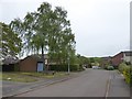
2
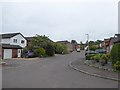
Fox Way, Nether Stowey
Part of a housing estate south of the village centre
Image: © David Smith
Taken: 11 May 2018
0.16 miles
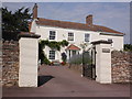
3
Old Farm Road, Nether Stowey
Part of a housing estate - presumably where there was once farmland
Image: © David Smith
Taken: 11 May 2018
0.19 miles
4
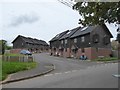
Highbeer Close, Nether Stowey
A development of terraced houses south of the village centre
Image: © David Smith
Taken: 11 May 2018
0.19 miles
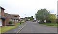
5
Oak Road, Nether Stowey
Part of a housing estate south of the old centre of the village
Image: © David Smith
Taken: 11 May 2018
0.20 miles
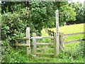
6
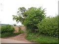
Field access and footpath to Cross Farm
The track leads to two fields; the path follows the hedge between these two
Image: © David Smith
Taken: 11 May 2018
0.21 miles
8
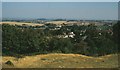
Towards Nether Stowey from the castle
From the motte (visible in the foreground), looking over trees towards the village. The nearest row of houses in the centre are on South Lane, just inside the square.
Image: © Derek Harper
Taken: 15 Sep 1996
0.22 miles