IMAGES TAKEN NEAR TO
/Bonsonwood Lane, BRIDGWATER, TA5 1JW
Introduction
This page details the photographs taken nearby to /Bonsonwood Lane, TA5 1JW by members of the Geograph project.
The Geograph project started in 2005 with the aim of publishing, organising and preserving representative images for every square kilometre of Great Britain, Ireland and the Isle of Man.

There are currently over 7.5m images from over14,400 individuals and you can help contribute to the project by visiting https://www.geograph.org.uk
Image Map
Images are licensed for reuse under creativecommons.org/licenses/by-sa/2.0
Notes
- Clicking on the map will re-center to the selected point.
- The higher the marker number, the further away the image location is from the centre of the postcode.
Image Listing (10 Images Found)
Images are licensed for reuse under creativecommons.org/licenses/by-sa/2.0
Image
Details
Distance
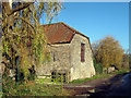
2
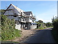
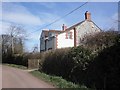
New house under construction at Coultings
Image: © Roger Cornfoot
Taken: 19 Sep 2012
0.07 miles
3
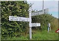
Old Direction Sign - Signpost by Coultings, Fiddington Parish
Pyramid finial - 3 arms; Somerset SCC pyramid by the UC road, in parish of Fiddington (Sedgemoor District), junction with Knaplock Lane, West of Coultings Farm.
Surveyed
Milestone Society National ID: SO_ST2241
Image: © Milestone Society
Taken: Unknown
0.08 miles
4
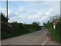
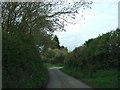
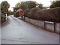
Road leading north from junction in Coultings
The speed derestriction sign at the edge of the hamlet is slightly optimistic, given the narrow lanes.
Image: © David Smith
Taken: 14 Apr 2011
0.09 miles
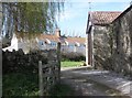
7
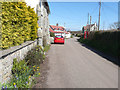
Bonsonwood lane with phone box behind photographer
Image: © Colin Bishop
Taken: 21 Sep 2006
0.15 miles