IMAGES TAKEN NEAR TO
Courtway, BRIDGWATER, TA5 1DR
Introduction
This page details the photographs taken nearby to TA5 1DR by members of the Geograph project.
The Geograph project started in 2005 with the aim of publishing, organising and preserving representative images for every square kilometre of Great Britain, Ireland and the Isle of Man.

There are currently over 7.5m images from over14,400 individuals and you can help contribute to the project by visiting https://www.geograph.org.uk
Image Map (Loading...)


Getting Data...Please wait
Leaflet Map data © OpenStreetMap
Images are licensed for reuse under creativecommons.org/licenses/by-sa/2.0
Notes
- Clicking on the map will re-center to the selected point.
- The higher the marker number, the further away the image location is from the centre of the postcode.
Image Listing (11 Images Found)
Images are licensed for reuse under creativecommons.org/licenses/by-sa/2.0
Image
Details
Distance
1
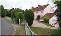
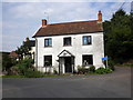
Cottage at Courtway
This cottage lies on the south eastern edge of the Quantocks but only about five miles north of Taunton.
Image: © Barbara Cook
Taken: 11 Aug 2006
0.02 miles
3
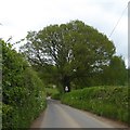
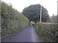
Three Horse Shoes Hill
A steep hill south of Courtway
Image: © David Smith
Taken: 11 May 2018
0.05 miles
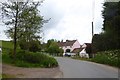
5
Junction, Courtway
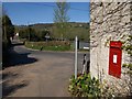
On the right is the George V postbox number TA5 80. This is on the side of the former post office at the junction of the lane from Merridge with the road down the valley to Lower Aisholt.
Image: © Derek Harper
Taken: 23 Apr 2010
0.06 miles
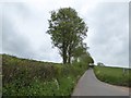
8
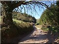
Lane to Lambridge Farm
The no through lane from Courtway runs along the valley side, with a small conifer plantation ahead.
Image: © Derek Harper
Taken: 23 Apr 2010
0.15 miles
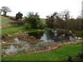
10
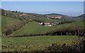
Lambridge Farm
The buildings to the left of the farmhouse in the valley bottom are in Image Beyond is Bishpool Farm, in Image Taken from the Samaritans Way South West as it follows Bridleway BW 30/30.
Image: © Derek Harper
Taken: 23 Apr 2010
0.21 miles