IMAGES TAKEN NEAR TO
High Street, BRIDGWATER, TA5 1BT
Introduction
This page details the photographs taken nearby to High Street, TA5 1BT by members of the Geograph project.
The Geograph project started in 2005 with the aim of publishing, organising and preserving representative images for every square kilometre of Great Britain, Ireland and the Isle of Man.

There are currently over 7.5m images from over14,400 individuals and you can help contribute to the project by visiting https://www.geograph.org.uk
Image Map
Images are licensed for reuse under creativecommons.org/licenses/by-sa/2.0
Notes
- Clicking on the map will re-center to the selected point.
- The higher the marker number, the further away the image location is from the centre of the postcode.
Image Listing (16 Images Found)
Images are licensed for reuse under creativecommons.org/licenses/by-sa/2.0
Image
Details
Distance
1
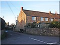
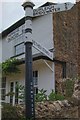
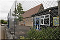
Methodist chapel and Sunday school , Spaxton
The Wesleyan Sunday school, now a garage, was built (in 1922), as the plaque shows, as a First World War memorial, while the chapel itself dates from 1858 http://webapp1.somerset.gov.uk/her/details.asp?prn=10202 & http://www.british-history.ac.uk/report.aspx?compid=18593 .
Image: © Derek Harper
Taken: 26 Jul 2010
0.03 miles
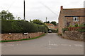
2
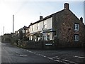
Old Direction Sign - Signpost on High Street, Spaxton
Lost finial - 1 arm; Somerset SCC pyramid by the UC road, in parish of Spaxton (Sedgemoor District), on the north side of the T junction of High Street and Pightley Road.
surveyed
Milestone Society National ID: SO_ST2236A
Image: © Milestone Society
Taken: Unknown
0.09 miles
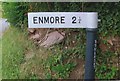
3
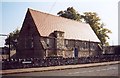
Old Direction Sign - Signpost in Spaxton
Pyramid finial - 3 arms; Somerset SCC pyramid by the UC road, in parish of Spaxton (Sedgemoor District), on the northwest side of the T junction of Bush Road and Peartwater Road.
surveyed
Milestone Society National ID: SO_ST2236B
Image: © Milestone Society
Taken: Unknown
0.13 miles
8
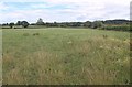
Field at Spaxton
A view from a gateway on Spaxton High Street, which runs past open countryside at several points. The view is looking along the slope of the Quantocks, which climb to the right.
Image: © Derek Harper
Taken: 26 Jul 2010
0.17 miles