IMAGES TAKEN NEAR TO
Aisholt, BRIDGWATER, TA5 1AR
Introduction
This page details the photographs taken nearby to TA5 1AR by members of the Geograph project.
The Geograph project started in 2005 with the aim of publishing, organising and preserving representative images for every square kilometre of Great Britain, Ireland and the Isle of Man.

There are currently over 7.5m images from over14,400 individuals and you can help contribute to the project by visiting https://www.geograph.org.uk
Image Map (Loading...)


Getting Data...Please wait
Leaflet Map data © OpenStreetMap
Images are licensed for reuse under creativecommons.org/licenses/by-sa/2.0
Notes
- Clicking on the map will re-center to the selected point.
- The higher the marker number, the further away the image location is from the centre of the postcode.
Image Listing (12 Images Found)
Images are licensed for reuse under creativecommons.org/licenses/by-sa/2.0
Image
Details
Distance
1
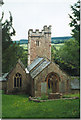
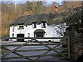
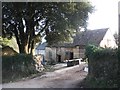
Aisholt Church
A magical little place. The walk over the ridge from Bagborough is fine. The churchyard is a local nature reserve.
Image: © Dave D
Taken: Unknown
0.04 miles
3
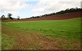
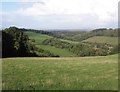
Fields above Aisholt
From the same spot as Image, looking to the left towards Aisholt Wood.
Image: © Derek Harper
Taken: 26 Apr 2014
0.08 miles
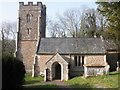
4
Aisholt from the Quantock crest
From the Macmillan Way West as it runs beside a wood on the ridge top of the Quantocks between Wills Neck and Lydeard Hill. The tower of Image is beside Aisholt Wood.
Image: © Derek Harper
Taken: 9 Apr 2005
0.10 miles
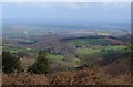
10
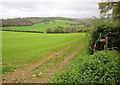
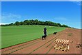
Field near Aisholt
The sign indicates the start of footpath BW 30/40. The field slopes away into the Lower Aisholt valley. Across the valley is woodland on Hawkridge Common. This is taken from the lane between Aisholt and Lower Aisholt.
Image: © Derek Harper
Taken: 26 Apr 2014
0.22 miles