IMAGES TAKEN NEAR TO
Woolston, TAUNTON, TA4 4LP
Introduction
This page details the photographs taken nearby to Woolston, TA4 4LP by members of the Geograph project.
The Geograph project started in 2005 with the aim of publishing, organising and preserving representative images for every square kilometre of Great Britain, Ireland and the Isle of Man.

There are currently over 7.5m images from over14,400 individuals and you can help contribute to the project by visiting https://www.geograph.org.uk
Image Map
Images are licensed for reuse under creativecommons.org/licenses/by-sa/2.0
Notes
- Clicking on the map will re-center to the selected point.
- The higher the marker number, the further away the image location is from the centre of the postcode.
Image Listing (11 Images Found)
Images are licensed for reuse under creativecommons.org/licenses/by-sa/2.0
Image
Details
Distance
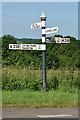
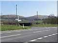
3
SCC Fingerpost at Woolson Moor A358
4 fingered post with SCC Cap.
Image: © Andrew Riley
Taken: 3 Jun 2018
0.08 miles
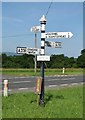
4
SCC Fingerpost at Wooston Moor
New detail submitted to Milestone Society.
Image: © Andrew Riley
Taken: 3 Jun 2018
0.08 miles
6
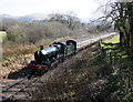
'Erlestoke Manor' drifts down the incline, with a train for Minehead
Image: © Roger Cornfoot
Taken: 19 Mar 2011
0.16 miles
7
A train from Williton climbes the incline towards Stogumber
Image: © Roger Cornfoot
Taken: 6 Nov 2010
0.17 miles
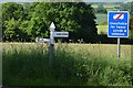
8
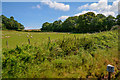
Bicknoller : Grassy Field
A grassy field in the Bicknoller Parish.
Image: © Lewis Clarke
Taken: 12 Jul 2019
0.18 miles
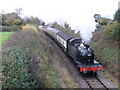
9
4160 climbs the steep incline, towards Stogumber
Image: © Roger Cornfoot
Taken: 19 Mar 2011
0.18 miles
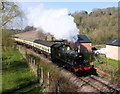
10

Woolston
Steam train passing Woolston on the West Somerset Railway.
Image: © Wayland Smith
Taken: 9 Jun 2013
0.19 miles