IMAGES TAKEN NEAR TO
/Combe Close, TAUNTON, TA4 4JE
Introduction
This page details the photographs taken nearby to /Combe Close, TA4 4JE by members of the Geograph project.
The Geograph project started in 2005 with the aim of publishing, organising and preserving representative images for every square kilometre of Great Britain, Ireland and the Isle of Man.

There are currently over 7.5m images from over14,400 individuals and you can help contribute to the project by visiting https://www.geograph.org.uk
Image Map
Images are licensed for reuse under creativecommons.org/licenses/by-sa/2.0
Notes
- Clicking on the map will re-center to the selected point.
- The higher the marker number, the further away the image location is from the centre of the postcode.
Image Listing (20 Images Found)
Images are licensed for reuse under creativecommons.org/licenses/by-sa/2.0
Image
Details
Distance
1
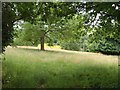
Field above Monksilver
A meadow with trees near Stanishmoor Copse, glimpsed across Combecross Hill from Image
Image: © Derek Harper
Taken: 30 Jun 2010
0.02 miles
2
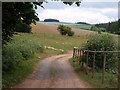
View from Combecross Hill
A driveway off the lane allows a view across fields towards the Willet valley, with a blue field of flax also visible in Image
Image: © Derek Harper
Taken: 30 Jun 2010
0.05 miles
3

EMN Hall, Monksilver
Elworthy, Monksilver and Nettlecombe Community Hall, shared between the three villages but located just southeast of Monksilver. An impressive modern design.
Image: © Derek Harper
Taken: 30 Jun 2010
0.07 miles
4

EMN Hall, Monksilver
Another view of Image from the edge of the car park. If you don't arrive by car there is a handy footpath from Monksilver alongside Combecross Hill.
Image: © Derek Harper
Taken: 30 Jun 2010
0.07 miles
5
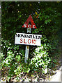
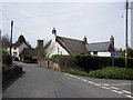
Old Village Signpost by the B3183, Combehill Cross, Monksilver Parish
Warning triangle finial - Somerset village sign by the B3183, in parish of Monksilver (West Somerset District), Combecross Hill, southern approach to village, in hedge.
Grade II Listed. List Entry Number: 1057564
https://historicengland.org.uk/listing/the-list/list-entry/1057564
Surveyed
Milestone Society National ID: SO_ST0737B
Image: © Alan Rosevear
Taken: 11 Oct 2013
0.10 miles
6
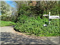
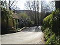
Lane to Stogumber leaving the B3188 at Monksilver
Image: © Rob Purvis
Taken: 15 Apr 2014
0.11 miles
7
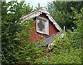
Tin Tabernacle at Monksilver
A virtually overgrown chapel at the junction of Combecross Hill and the B3188, currently unreachable unless armed with stout gardening tools. There are two much clearer photos of the building at http://members.multimania.co.uk/dbown100/monksilverAlbum101.jpg .
Image: © Derek Harper
Taken: 30 Jun 2010
0.11 miles
8
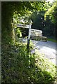
Direction Sign - Signpost on the B3188 in Monksilver
Pyramid finial - 3 arms; Somerset SCC pyramid by the B3188, in parish of Monksilver (West Somerset District), Combehill Cross, southern approach to village. See also https://www.flickr.com/photos/tollhouses/10223330974. By 2021 the Williton, Watchet, Minehead arm had broken off.
Surveyed
Milestone Society National ID: SO_ST0737C
Image: © A Rosevear
Taken: 11 Oct 2013
0.12 miles