IMAGES TAKEN NEAR TO
Nettlecombe, TAUNTON, TA4 4HP
Introduction
This page details the photographs taken nearby to Nettlecombe, TA4 4HP by members of the Geograph project.
The Geograph project started in 2005 with the aim of publishing, organising and preserving representative images for every square kilometre of Great Britain, Ireland and the Isle of Man.

There are currently over 7.5m images from over14,400 individuals and you can help contribute to the project by visiting https://www.geograph.org.uk
Image Map (Loading...)


Getting Data...Please wait
Leaflet Map data © OpenStreetMap
Images are licensed for reuse under creativecommons.org/licenses/by-sa/2.0
Notes
- Clicking on the map will re-center to the selected point.
- The higher the marker number, the further away the image location is from the centre of the postcode.
Image Listing (5 Images Found)
Images are licensed for reuse under creativecommons.org/licenses/by-sa/2.0
Image
Details
Distance
1
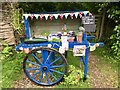
Roadside stall
Local fresh produce was for sale on the day we saw this pretty honesty stall. The young courgettes were delicious.
Image: © Marika Reinholds
Taken: 31 Jul 2021
0.18 miles
2
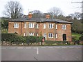
Stone cottages on the B3188 at Woodford
Image: © Roger Cornfoot
Taken: 17 Mar 2014
0.22 miles
5

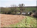
Direction Sign – Signpost on the B3188 in Yarde
Located on a grass triangle in the centre of the T junction on the B3188 opposite Yarde Mill House in Yarde village in Nettlecombe parish. 3 arms and pyramid finial.
Milestone Society National ID: SO_ST0639
Image: © A Rosevear
Taken: 3 Apr 2009
0.24 miles