IMAGES TAKEN NEAR TO
/Church Close, TAUNTON, TA4 3SF
Introduction
This page details the photographs taken nearby to /Church Close, TA4 3SF by members of the Geograph project.
The Geograph project started in 2005 with the aim of publishing, organising and preserving representative images for every square kilometre of Great Britain, Ireland and the Isle of Man.

There are currently over 7.5m images from over14,400 individuals and you can help contribute to the project by visiting https://www.geograph.org.uk
Image Map
Images are licensed for reuse under creativecommons.org/licenses/by-sa/2.0
Notes
- Clicking on the map will re-center to the selected point.
- The higher the marker number, the further away the image location is from the centre of the postcode.
Image Listing (20 Images Found)
Images are licensed for reuse under creativecommons.org/licenses/by-sa/2.0
Image
Details
Distance
1
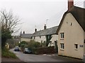
Lydeard St Lawrence
The main village street. The row of cottages on the right was, originally, a C16 farmhouse http://webapp1.somerset.gov.uk/her/details.asp?prn=17475 .
Image: © Derek Harper
Taken: 14 Dec 2009
0.02 miles
3
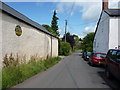
AA village sign at Lydeard St Lawrence
Between 1906 and 1922,The Automobile Association erected almost 30000 signs, like the one seen on the left here, in villages and towns across the country. The majority were removed in WWII. Approximately 65 remain in situ. http://www.cvphm.org/AAVillageSigns.html
Image: © Phil Champion
Taken: 19 Jul 2009
0.03 miles
5
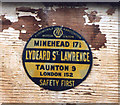
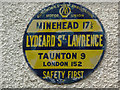
Old circular AA and Motor Union Sign in Lydeard St Lawrence
Old AA and Motor Union Sign on the wall of a garage on the west side of the road in Lydeard St Lawrence, 8 miles northwest of Taunton. Lydeard St. Lawrence parish.
This is a circular type but not quite conforming to the other two circular styles, showing distances Minehead 17½ Taunton 9 London 152.
There were five series of AA signs, mostly dating from 1923 and made by Francis & Co / Franco in Deptford, London. The village name and distance to London were usually displayed. Information on the Motor Union of Great Britain and Ireland is here https://www.gracesguide.co.uk/Motor_Union_of_Great_Britain_and_Ireland.
See also https://www.flickr.com/photos/pluralzed/4693981171 , https://www.flickr.com/photos/pluralzed/4694612760 and https://www.geograph.org.uk/photo/1707175.
Milestone Society National ID: SO-LYDSTL
Image: © Milestone Society
Taken: Unknown
0.03 miles
8
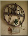
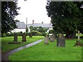
Bell wheel, Lydeard St Lawrence church
An old wheel for the tenor bell hangs in the nave of St Lawrence's church, "complete with the end of the headstock, gudgeon and stock hoop" http://www.bellhistorians.org.uk/junk.htm . "The old bell clappers ... were removed from the bell chamber in 1982, when the bells were increased to a ring of six" (from the church guide). Beneath is a plan of the church.
Image: © Derek Harper
Taken: 14 Dec 2009
0.06 miles
9
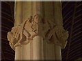
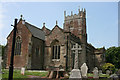
Capital, Lydeard St Lawrence church
Angels decorate this capital in the north aisle of Image The chancel and nave of the church are C14.
Image: © Derek Harper
Taken: 14 Dec 2009
0.06 miles
10
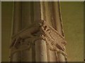
Capital, Lydeard St Lawrence church
A fox catches a goose on the capital at the west end of the north aisle of Image See Image for the next capital along.
Image: © Derek Harper
Taken: 14 Dec 2009
0.06 miles