IMAGES TAKEN NEAR TO
Lydeard St. Lawrence, TAUNTON, TA4 3QQ
Introduction
This page details the photographs taken nearby to TA4 3QQ by members of the Geograph project.
The Geograph project started in 2005 with the aim of publishing, organising and preserving representative images for every square kilometre of Great Britain, Ireland and the Isle of Man.

There are currently over 7.5m images from over14,400 individuals and you can help contribute to the project by visiting https://www.geograph.org.uk
Image Map
Images are licensed for reuse under creativecommons.org/licenses/by-sa/2.0
Notes
- Clicking on the map will re-center to the selected point.
- The higher the marker number, the further away the image location is from the centre of the postcode.
Image Listing (8 Images Found)
Images are licensed for reuse under creativecommons.org/licenses/by-sa/2.0
Image
Details
Distance
1
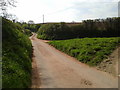
Channel to Channel (466)
This is the way taken to the road at Lower Preston Farm.
Image: © Shazz
Taken: 30 Apr 2015
0.08 miles
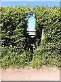
2

Channel to Channel (465)
A weathercock at Lower Preston Farm is seen here.
Image: © Shazz
Taken: 30 Apr 2015
0.08 miles
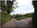
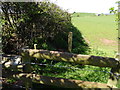
3
Channel to Channel (467)
This stile is taken to go north.
Image: © Shazz
Taken: 30 Apr 2015
0.10 miles
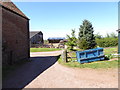
4
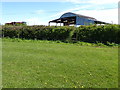
Channel to Channel (468)
Here the camera is looking back to a barn at Lower Preston Farm.
Image: © Shazz
Taken: 30 Apr 2015
0.10 miles
5
Channel to Channel (469)
Here's another stile, another field, another view.
Image: © Shazz
Taken: 30 Apr 2015
0.16 miles
6
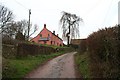
Preston Farm , south of Stogumber.
A typical Somerset farmhouse, recently refurbished and covered in limewash. The large tree is a weeping ash.
Image: © Barbara Cook
Taken: 19 Jan 2006
0.19 miles