IMAGES TAKEN NEAR TO
Coleford Water, TAUNTON, TA4 3QP
Introduction
This page details the photographs taken nearby to Coleford Water, TA4 3QP by members of the Geograph project.
The Geograph project started in 2005 with the aim of publishing, organising and preserving representative images for every square kilometre of Great Britain, Ireland and the Isle of Man.

There are currently over 7.5m images from over14,400 individuals and you can help contribute to the project by visiting https://www.geograph.org.uk
Image Map (Loading...)


Getting Data...Please wait
Leaflet Map data © OpenStreetMap
Images are licensed for reuse under creativecommons.org/licenses/by-sa/2.0
Notes
- Clicking on the map will re-center to the selected point.
- The higher the marker number, the further away the image location is from the centre of the postcode.
Image Listing (6 Images Found)
Images are licensed for reuse under creativecommons.org/licenses/by-sa/2.0
Image
Details
Distance
3
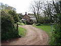
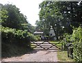
House at Coleford Water
The hamlet of Coleford Water consists of three or four houses. The lanes leading to it are single track with hardly any passing places.
Image: © Barbara Cook
Taken: 3 May 2006
0.06 miles
5
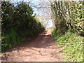
Green lane at Underhill Cross heading west
Image: © Rob Purvis
Taken: 16 Apr 2014
0.22 miles
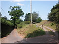
6
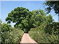
Lane to Willett
Trees overhang the lane as it climbs from Coleford Water.
Image: © Derek Harper
Taken: 3 Jun 2010
0.23 miles